Military and Traffic Maps
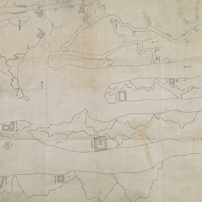
廣州至澳門水道圖
Map of the Waterways between Canton and Macao| Hanyu Pinyin | Guangzhou zhi Aomen shui dao tu |
|---|---|
| Date | The 22th year of Qing Jiaqing's reign, 1817 |
| Measurement | |
| Techniques | Pen-and-ink manuscript |
| Material | paper |
| Quantity | |
| Categories | |
| Country of Repository | |
| Identifier | British Library |
| Notes | Or. 7409 B |
| Share |
No title appears on this map; title applied here is based on content. There is no expressed scale or legend. Orientation depends on perspective but the north is basically at the right. The map depicts the waterways from the east fort in Panyu County, Guangzhou Prefecture, to the east and west banks of the Pearl River estuaries in Macao, flowing through counties such as Panyu, Shunde, Xiangshan (ref. Guangzhou Prefecture, Illustrated Atlas of Guangdong, Vol. I). Two notes on the right explains the east and west waterways. The east starts from the Thirteen Factories to the Pearl River estuaries in Macao, 420 li in length. The west starts from the east fort to Macao, 300 li in length. The map is drawn with ink where the temple, pagoda, military camps, and forts are sketched roughly. Due to the material in use, the paper is slightly damaged and yellowish.
The map especially stresses on the deployment of forts. This map seems not only a map of waterways, but serves the function of deploying military troops. This map is probably drawn around the 22nd year of Jiaqing’s reign, 1817. This map shares identical content with another map collected in the British Library (Add. MS. 16363 (B)) but the latter one is drawn rather hastily and shown several modification marks.
This map can be contrased with the following maps in the National Palace Museum’s collection: Guangdong Sheng shu ge zhou fu xian di yu tu shuo (map no.021157); Guangdong Sheng di tu (map no. 021477); Guangdong zhi Xianluo shui lu dao li tu (Grand Council file no. 010186); and the Library of Congress collection: Guangdong quan tu (gm 71005120); Guangdong tong sheng shui dao tu (gm 71002467); Guangdong quan sheng shui lu yu tu (gm 71005159).