Military and Traffic Maps
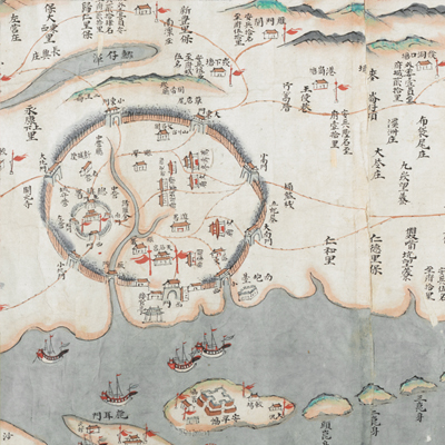
臺灣汛塘望寮圖
Garrison Watchtower and Platoon Map of Taiwan Island| Hanyu Pinyin | Taiwan xun tang wang liao tu |
|---|---|
| Date | The 40th – 51st year of Qing Qianlong's reign, 1775-1786. |
| Measurement | |
| Techniques | Ink and color manuscript |
| Material | paper |
| Quantity | |
| Categories | |
| Country of Repository | |
| Identifier | British Library |
| Link to Original Database | http://explore.bl.uk/primo_library/... |
| Notes | Add. MS. 16363 (D) |
| Share |
No title appears on this map; the title applied here is based on content. No scale, legend, or orientation is given; but obviously north it at the left. Since the perspective is from Fujian through the strait, Taiwan Island is in the shape of a long horizontal rectangle. The map covers the area from Dajilong Battalon and coastal islands in the north to Shamajitou, Xianren Mountains, and Guibiqi in the south, from the Central Mountain Range in the East to the Taiwan Straits and surrounding islands in the west. The map uses a traditional Chinese pictorial style to depict mountains, cities, checkpoints, settlements, and salt fields. Wide red lines from Alishipu to Fangliaokou Platoon and the green lines from Puzili Mountains to Shiqiu Mountains indicate boundaries between Han Chinese and Taiwanese aborigines; thin dashed lines indicate roads on the island. Place names, checkpoints, numbers of soldiers stationed at flood posts, and mileages are marked. The map drawn in great detail is almost a complete early map of Taiwan.
Wooden fences were already built in four counties and Tamsui Sub-prefecture. Based on the name of Zhuluo and the materials used for the town walls shown on the map, the map may have been drawn during the 40th and the 51st year of Qing Qianlong’s reign, 1775-1786.
This map can be studied with the following maps in the National Palace Museum’s collection: Taiwan lue tu (map no. 021444, 021445); Yongzheng Taiwan tu fu Penghu qun dao tu (map no. 020794); Qianlong Taiwan di tu (map no. 020795); Zhong xiu Tai Jun ge jian zhu tu shuo (map no. 020970-021048); Fujian Sheng di tu (map no. 021476); and the Library of Congress collection: Taiwan qian hou shan quan tu (gm 71005066); Taiwan di li tu (gm 71005037); Taiwan qian hou shan yu tu (gm 71005160).