Military and Traffic Maps
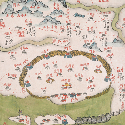
臺灣府汛塘圖
Garrison Map of Taiwan Prefecture| Hanyu Pinyin | Taiwan Fu xun tang tu |
|---|---|
| Date | Between late Qing Yongzheng and early Qianlong period, 1735-1759. |
| Measurement | |
| Techniques | Ink and color manuscript |
| Material | paper |
| Quantity | |
| Categories | |
| Country of Repository | |
| Identifier | British Library |
| Notes | Or. 11295 |
| Share |
No title appears on this map; the title applied here is based on content. No scale, legend, or orientation is given, but obviously north it at the left. Since the perspective is from Fujian through the strait, Taiwan Island is in the shape of a long horizontal rectangle. The map covers the island from Guilong Town and coastal islands in the north to Shamajitou in the south, from Central Mountain Range in the East to Taiwan Strait and Penghu Islands (Pescadores Islands) in the west. Place names are marked in red throughout the map while the rest of information is in black ink, such as numbers of soldiers stationed at flood posts, road mileage, the remaining number of aboriginal community, and different years they were naturalized into Qing Dynasty. Wooden fences were already built in four counties and Tamsui and Penghu Sub-prefectures; the map may have been drawn during Late Qing Yongzheng and Early Qianlong period, 1735-1759.
This map can be contrasted with the following maps in the National Palace Museum’s collection: Taiwan lue tu (map no. 021444, 021445); Yongzheng Taiwan tu fu Penghu qun dao tu (map no. 020794); Qianlong Taiwan di tu (map no. 020795); Zhong xiu tai jun ge jian zhu tu shuo (map no. 020970-021048); Fujian Sheng di tu (map no. 021476); and the Library of Congress collection: Taiwan qian hou shan quan tu (gm 71005066); Taiwan di li tu (gm 71005037); Taiwan qian hou shan yu tu (gm 71005160).
This map can be contrasted with the following maps in the National Palace Museum’s collection: Taiwan lue tu (map no. 021444, 021445); Yongzheng Taiwan tu fu Penghu qun dao tu (map no. 020794); Qianlong Taiwan di tu (map no. 020795); Zhong xiu tai jun ge jian zhu tu shuo (map no. 020970-021048); Fujian Sheng di tu (map no. 021476); and the Library of Congress collection: Taiwan qian hou shan quan tu (gm 71005066); Taiwan di li tu (gm 71005037); Taiwan qian hou shan yu tu (gm 71005160).