Military and Traffic Maps
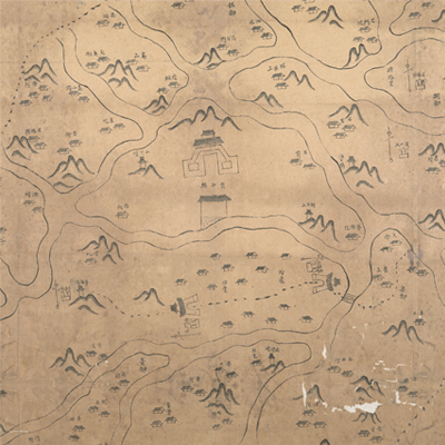
雲和縣境輿圖
Military Map of Yunhe County| Hanyu Pinyin | Yunhe Xian jing yu tu |
|---|---|
| Date | After the 49th year of Qing Kangxi's reign, 1710-. |
| Measurement | |
| Techniques | Pen-and-ink manuscript |
| Material | paper |
| Quantity | |
| Categories | |
| Country of Repository | |
| Identifier | British Library |
| Link to Original Database | http://explore.bl.uk/primo_library/... |
| Notes | Add. MS. 16359 (B) |
| Share |
No title appears on this map; the title applied here is based on content. Scale and legend are not given; annotation and orientation are written along the borders on all four sides with north at the top. Yunhe County was under the jurisdiction of Chuzhou Prefecture in Zhejiang Province. It was located 110 li northeast of the prefectural seat. It was 80 li wide from east to west; 70 li long from north to south. The map offers pictorial depictions of town gates, military posts, mountains, and temples in the whole county with annotations indicating place names. Drawn in simple and rustic strokes, the map is mainly to describe military posts. The map may have been an early official county map.
The map shows the gates built in the 27th year of Kangxi’s reign, 1688, and the military posts established in the 49th year of Kangxi’s reign, 1710, but not the official bureaus and temples built after the Yongzheng period. The map may have been drawn in late Kangxi period, 1710.
This map can be contrasted with the following maps in the National Palace Museum’s collection: Zhejiang Chuzhou Fu shu di li yu tu (map no. 020969); Zhejiang Chuzhou Fu di yu tu shuo (map no. 021311); Zhejiang Chuzhou Fu dao li tu (map no. 021497); Zhejiang quan sheng dao li zong tu (map no. 021505-021506); Zhejiang quan sheng tu (map no. 021589); and the Library of Congress collection: Zheijiang quan tu (gm 71005029); Zhejiang yan hai yao kou quan tu (gm 2002626763); Qiantangjian yan an tu (gm 71005077).