Military and Traffic Maps
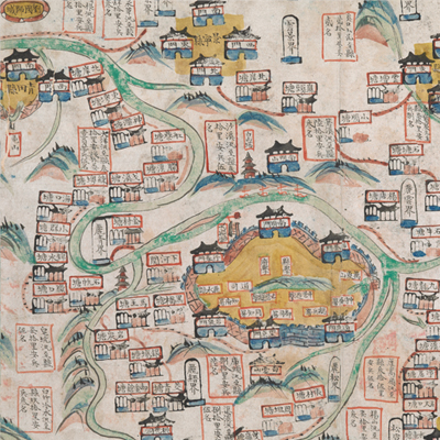
處州府屬全境塘汛輿圖
Military Map of Chuzhou Prefecture| Hanyu Pinyin | Chuzhou Fu shu quan jing tang xun yu tu |
|---|---|
| Date | After the 15th year of Qing Jiaqing's reign, 1810-. |
| Measurement | |
| Techniques | Ink and color manuscript |
| Material | paper |
| Quantity | |
| Categories | |
| Country of Repository | |
| Identifier | British Library |
| Link to Original Database | http://explore.bl.uk/primo_library/... |
| Notes | Add. MS. 16361 (B) |
| Share |
No title appears on this map; the title applied here is based on content. Scale, legend, and orientation are not given; but north is at the bottom, based on the annotation and locations on the map. The map depicts 10 counties of Chuzhou prefecture pictorially, including Lishui, Qingyuan, Yunhe, Jingning, Qingtian, Longquan, Suichang, Songyang, Xuanping, Jinyun. No town wall was drawn for Jingning, Yunhe, Longquan, Suichang, Songyang, Xuan Ping, and Jinyun counties; only their four direction gates and county names were indicated. A gate was erased from the map because Jinyun County lack of west gate. There are also detailed illustrations of each checkpoint with locations identified and number of soldiers noted. There is a great deal of information on the location of military posts. The map may have been drawn around the 15th year of Qing Jiaqing’s reign, 1810.
This map can be studied with the following maps in the National Palace Museum’s collection: Zhejiang Chuzhou Fu shu di li yu tu (map no. 020969); Zhejiang Chuzhou Fu di yu tu shuo (map no. 021311); Zhejiang Chuzhou Fu dao li tu (map no. 021497); Zhejiang quan sheng dao li zong tu (map no. 021505-021506); Zhejiang quan sheng tu (map no. 021589); and the Library of Congress collection: Zheijiang quan tu (gm 71005029); Zhejiang yan hai yao kou quan tu (gm 2002626763); Qiantangjian yan an tu (gm 71005077).
This map can be studied with the following maps in the National Palace Museum’s collection: Zhejiang Chuzhou Fu shu di li yu tu (map no. 020969); Zhejiang Chuzhou Fu di yu tu shuo (map no. 021311); Zhejiang Chuzhou Fu dao li tu (map no. 021497); Zhejiang quan sheng dao li zong tu (map no. 021505-021506); Zhejiang quan sheng tu (map no. 021589); and the Library of Congress collection: Zheijiang quan tu (gm 71005029); Zhejiang yan hai yao kou quan tu (gm 2002626763); Qiantangjian yan an tu (gm 71005077).