Military and Traffic Maps
金華協及所轄營汛圖
Military Map of Jinhua Brigade| Hanyu Pinyin | Jinhua xie ji suo xia ying xun tu |
|---|---|
| Date | Around the 50th year of Qing Qianlong's reign, 1785. |
| Measurement | |
| Techniques | Ink and color manuscript |
| Material | paper |
| Quantity | |
| Categories | |
| Country of Repository | |
| Identifier | British Library |
| Link to Original Database | http://explore.bl.uk/primo_library/... |
| Notes | Add. MS. 16361 (D) |
| Share |
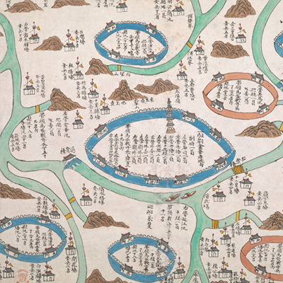
No title appears on this map; the title applied here is based on content. Scale and legend are not given; orientation and annotations are marked along the borders on all four sides with north at the top. The map depicts some features pictorially, including Jinhua prefectural capital and its governing counties of Tangxi, Wuyi, Yongkang, Dongyang, Yiwu, and Pujiang, and military posts in each counties. The map locates the seven counties under the jurisdiction of Jinhua Prefecture, except Lanxi County.
The number of soldiers stationed throughout the small posts is clearly annotated on the map. Military posts are represented by symbol of houses; mountains are depicted in the Chinese stylized brush expressions of shade and texture known as Cunfa style. The Dongyang River flows westward from the north of Dongyang County, to the south of Yiwu County. Two patrol boats are depicted on the river. This is an official military station map. Walls are depicted in two different colors: blue walls with battlements and yellow walls made of rammed-earth without battlements. Based on the number of soldiers at each post, the map may have been drawn around the 50th year of Qing Qianlong’s reign, 1785.
This map can be contrasted with the following maps in the National Palace Museum’s collection: Zhejiang Jinhua Fu dao li tu (map no. 021498); Zhejiang quan sheng dao li zong tu (map no. 021505-021506); Zhejiang Jinhua Fu ba yi di li tu (map no. 021521); Zhejiang quan sheng tu (map no. 021589); and the Library of Congress collection: Zheijiang quan tu (gm 71005029); Zhejiang yan hai yao kou quan tu (gm 2002626763); Ning Jun di yu tu (gm 71002469); Qiantangjian yan an tu (gm 71005077); Jiang hai quan tu (gm 71005059).