Military and Traffic Maps
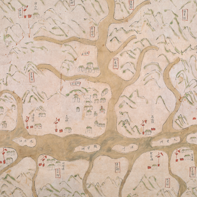
桐廬縣境輿圖
Military Map of Tonglu County| Hanyu Pinyin | Tonglu Xian jing yu tu |
|---|---|
| Date | Qing Daoguang period, 1821-1843. |
| Measurement | |
| Techniques | Ink and color manuscript |
| Material | paper |
| Quantity | |
| Categories | |
| Country of Repository | |
| Identifier | British Library |
| Link to Original Database | http://explore.bl.uk/primo_library/... |
| Notes | Add. MS. 16358 ( E) |
| Share |
No title appears on this map; the title applied here is based on content. Scale and legend are not given; orientation is marked along the borders on all four sides with north at the top. Tonglu County was under the jurisdiction of Yanzhou Prefecture, Zhejiang Province. The territory covered 90 li from east to west, and 132 li from north to south; eleven villages and five townships are included.
The map depicts Tonglu with simple images, including mountains, military posts, and villages. The rivers are colored in yellowish brown; the largest Fuchun River and its branch Tong River are conspicuously depicted on the map. The map locates military units in detail; it is an official military map. Tonglu’s capital town had no town wall, a rare occurrence for a county. There isn’t enough information on the map to give accurate date estimation, but the map may have been drawn during the Qing Daoguang period, 1821- 1843.
This map can be contrasted with the following maps in the National Palace Museum’s collection: Zhejiang Yanzhou Fu dao li tu (map no. 021495); Zhejiang quan sheng dao li zong tu (map no. 021505-6); Zhejiang quan sheng tu (map no. 021589); and the Library of Congress collection: Zheijiang quan tu (gm 71005029); Zhejiang yan hai yao kou quan tu (gm 2002626763); Ning Jun di yu tu (gm 71002469); Qiantangjian yan an tu (gm 71005077); Jiang hai quan tu (gm 71005059).