Military and Traffic Maps
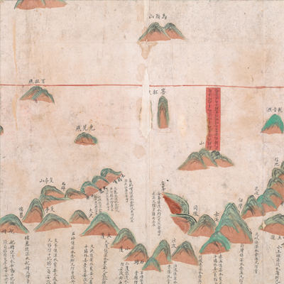
平陽營沿海界址圖
Coastal Map of Pingyang Brigade| Hanyu Pinyin | Pingyang Ying yan hai jie zhi tu |
|---|---|
| Date | After the fourth year of Qing Qianlong's reign, 1739-. |
| Measurement | |
| Techniques | Ink and color manuscript |
| Material | paper |
| Quantity | |
| Categories | |
| Country of Repository | |
| Identifier | British Library |
| Link to Original Database | http://explore.bl.uk/primo_library/... |
| Notes | Add. MS. 16358 (G) |
| Share |
The title is written on a red label in black ink. Scale and legend are not given; orientation is marked along the borders on all four sides with north at the left. The map offers a pictorial depiction of the coast line of Pingyang County, Wenzhou Prefecture in Zhejiang Province. All place names are identified; annotations record water depths, brigade jurisdictions, water depth, and troop staffing. Red lines are used to mark the jurisdictions and boundaries of Pingyang County, Rui’an County and Fuding County; one red label affixed to the map indicates the division of inner ocean and overseas. Based on the information, the map is an official military map.
The land area on the map is under the jurisdiction of Pingyang Brigade, which is bordered by Songbu Brigade to the east, Zhenxiakwan to the south, Fenshui Brigade to the west, and Feiyundu to the north. Since Fuding County mentioned on the map was not established until the fourth year of Qing Qianlong’s reign, 1739, the map must have been drawn after 1739.
This map can be contrasted with the following maps in the National Palace Museum’s collection: Zhejiang Wenzhou Fu shu di li yu tu (map no. 020968); Zhejiang Wenzhou Fu shu di yu tu shuo (map no. 021312); Wenzhou Fu dao li tu (map no. 021496); Zhejiang quan sheng dao li zong tu (map no. 021505-021506); and the Library of Congress collection: Zheijiang quan tu (gm 71005029); Zhejiang yan hai yao kou quan tu (gm 2002626763); Ning Jun di yu tu (gm 71002469); Qiantangjian yan an tu (gm 71005077); Jiang hai quan tu (gm 71005059).