Military and Traffic Maps
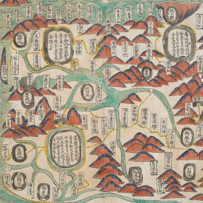
平陽營輿圖
Military Map of Pingyang Brigade| Hanyu Pinyin | Pingyang Ying yu tu |
|---|---|
| Date | After the 25th year of Qing Qianlong's reign, 1760-. |
| Measurement | |
| Techniques | Ink and color manuscript |
| Material | paper |
| Quantity | |
| Categories | |
| Country of Repository | |
| Identifier | British Library |
| Link to Original Database | http://explore.bl.uk/primo_library/... |
| Notes | Add. MS. 16362 (B) |
| Share |
Title is written on the map. Scale and legend are not given; orientation is written along the borders on all four sides with north at the bottom. The map offers pictorial depictions of mountains, sea waves, Pingyang Brigade, and its affiliated battalions. Military posts and checkpoints are annotated; places and military staffing levels are also annotated on the map. The map may be a part of a set. Pingyang County was under the jurisdiction of Wenzhou Prefecture, and was situated 130 li southwest of Wenzhou prefectural seat. Pingyang’s jurisdiction area was bordered by Songbu battalion (i.e. a branch of Rui’an Brigade) to the east, Zhenxiakwan (i.e. a Fukien Brigade) to the south, Fenshuikwan (i.e. Tongshan Brigade) to the west, and Feiyun Ferry (i.e. Rui’an Brigade) to the north. The map may have been drawn around the 25th year of Qing Qianlong’s reign, 1760.
This map can be contrasted with the following maps in the National Palace Museum’s collection: Zhejiang Wenzhou Fu shu di li yu tu (map no. 020968); Zhejiang Wenzhou Fu shu di yu tu shuo (map no. 021312); Wenzhou Fu dao li tu (map no. 021496); Zhejiang quan sheng dao li zong tu (map no. 021505-021506); Zhejaing quan sheng tu (map no. 021589); and the Library of Congress collection: Zheijiang quan tu (gm 71005029); Zhejiang yan hai yao kou quan tu (gm 2002626763); Ning Jun di yu tu (gm 71002469); Qiantangjian yan an tu (gm 71005077); Jiang hai quan tu (gm 71005059).
This map can be contrasted with the following maps in the National Palace Museum’s collection: Zhejiang Wenzhou Fu shu di li yu tu (map no. 020968); Zhejiang Wenzhou Fu shu di yu tu shuo (map no. 021312); Wenzhou Fu dao li tu (map no. 021496); Zhejiang quan sheng dao li zong tu (map no. 021505-021506); Zhejaing quan sheng tu (map no. 021589); and the Library of Congress collection: Zheijiang quan tu (gm 71005029); Zhejiang yan hai yao kou quan tu (gm 2002626763); Ning Jun di yu tu (gm 71002469); Qiantangjian yan an tu (gm 71005077); Jiang hai quan tu (gm 71005059).