Military and Traffic Maps
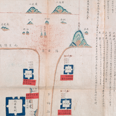
溫州府瑞安縣海圖
Yongzheng Sea Map of Rui’an County| Hanyu Pinyin | Wenzhou Fu Rui’an Xian hai tu |
|---|---|
| Date | After the ninth year of Qing Yongzheng's reign, 1731-. |
| Measurement | |
| Techniques | Ink and color manuscript on paper, mountedon silk |
| Material | paper |
| Quantity | |
| Categories | |
| Country of Repository | |
| Identifier | British Library |
| Notes | Or. 13159 (1) |
| Share |
The title is revised from which written on a red label affixed in black ink. Scale and legend are not given; orientation is marked along the borders on three sides with north at the left. The Rui’an County seal in both Chinese and Manchu is stamped on the top. The map offers pictorial depictions of Rui’an County capital, brigades, custom offices, temples, and mountains. Explanatory text on the right records distances from different places to the sea. The map covers the area from the sea in the east to the bank of Wenzhou in the west; and from the junction of Siyu and Pingyang Counties in the south to the junction of Beiyangjiao and Yongchia Counties in the north. This area was Wenzhou Left Brigade’s ocean patrol range. Red labels affixed to the brigades record troop staffing level.
Rui’an Brigade was changed to a naval force in the second year of Qing Yongzheng’s reign, 1724. The map may have been drawn after the ninth year of Qing Yongzheng’s reign, 1731, the year Wenzhou Left Brigade changed to a naval force.
This map can be studied with the following maps in the National Palace Museum’s collection: Zhejiang Wenzhou Fu shu di li yu tu (map no. 020968); Zhejiang Wenzhou Fu shu di yu tu shuo (map no. 021312); Wenzhou Fu dao li tu (map no. 021496): Zhejiang quan sheng dao li zong tu (map no. 021505-021506); Zhejiang quan sheng tu (map no. 021589); and the Library of Congress collection: Zheijiang quan tu (gm 71005029); Zhejiang yan hai yao kou quan tu (gm 2002626763); Ning Jun di yu tu (gm 71002469); Qiantangjian yan an tu (gm 71005077); Jiang hai quan tu (gm 71005059).