Military and Traffic Maps
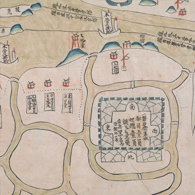
磐石營城汛四至交界圖
Military Map of Panshi Regiment| Hanyu Pinyin | Panshi Ying cheng xun si zhi jiao jie tu |
|---|---|
| Date | Around the sixth year of Qing Yongzheng's reign, 1728. |
| Measurement | |
| Techniques | Ink and color manuscript |
| Material | paper |
| Quantity | |
| Categories | |
| Country of Repository | |
| Identifier | British Library |
| Link to Original Database | http://explore.bl.uk/primo_library/... |
| Notes | Add. MS. 16361 (K) |
| Share |
Title is written on a label in black ink and affixed to the map. Scale and legend are not given; orientation and annotation are written along the borders on all four sides with north at the bottom. The map offers pictorial depictions of settlements, military posts, and boundary markers. Annotations describe the jurisdictions of military units. Patrol boats between Ou River and Wenzhou Bay are depicted with images. Panshi Regiment was established in the first year of Qing Kangxi’s reign, 1662, to be responsible for coastal defense.
Panshi Regiment added three more units in the 56th year of Qing Kangxi’s reign, 1717; in 1724, Panshi Regiment became under the jurisdiction of Leqing Brigade. The map depicts Guantou Xun, Mashantang, and Shatou Xun under the jurisdiction of Leqing Brigade. The map was drawn after the sixth year of Qing Yongzheng’s reign, 1728. Each battalion inside and outside of the Wenzhou Bay’s middle line was identified.
This map can be contrasted with the following maps in the National Palace Museum’s collection: Zhejiang Wenzhou Fu shu di li yu tu (map no. 020968); Zhejiang Wenzhou Fu shu di yu tu shuo (map no. 021312); Wenzhou Fu dao li tu (map no. 021496); Zhejiang quan sheng dao li zong tu (map no. 021505-021506); Zhejaing quan sheng tu (map no. 021589); and the Library of Congress collection: Zheijiang quan tu (gm 71005029); Zhejiang yan hai yao kou quan tu (gm 2002626763); Ning Jun di yu tu (gm 71002469); Qiantangjian yan an tu (gm 71005077); Jiang hai quan tu (gm 71005059).