Military and Traffic Maps
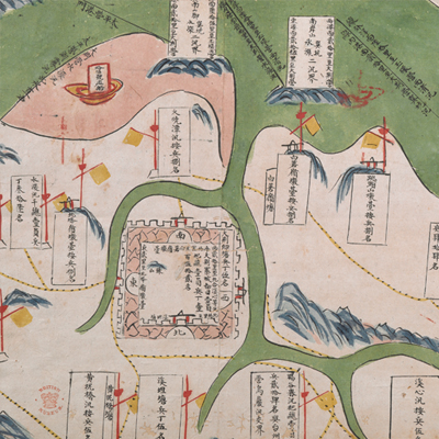
大荊營水陸輿圖
Military Map of Dajing Regiment| Hanyu Pinyin | Dajing Ying shui lu yu tu |
|---|---|
| Date | The 20th-28th year of Qing Qianlong's reign, 1755-1763. |
| Measurement | |
| Techniques | Ink and color manuscript |
| Material | paper |
| Quantity | |
| Categories | |
| Country of Repository | |
| Identifier | British Library |
| Notes | Add. MS. 16369 (B) |
| Share |
Title is written on the map. Scale and legend are not given; orientation and annotation are written along the borders on all four sides with north at the bottom. The map offers pictorial depictions of the capital town of Dajing Regiment, piers, military posts, mountains, and rivers. Dajing Regiment was under the jurisdiction of Wenzhou Division, and covers the area 17 li from Taiping Regiment to the east, 63 li from Leqing Brigade to the south, 60 li from Chengfang Ridge in Wenzhou Brigade to the west, 30 li from Panshan Ridge in Taiping Regiment to the north.
Dajing Regiment was situated inside the Dajing Settlements, with a force of 245 soldiers and 100 cavalrymen in the 20th year of Qing Qianlong’s reign, 1755. It became under the jurisdiction of Leqing Brigade. The map may be drawn between the 20th to the 28th year of Qing Qianlong’s reign 1755-1763.
This map can be contrasted with the following maps in the National Palace Museum’s collection: Zhejiang Wenzhou Fu shu di li yu tu (map no. 020968); Zhejiang Wenzhou Fu shu di yu tu shuo (map no. 021312); Wenzhou Fu dao li tu (map no. 021496); Zhejiang quan sheng dao li zong tu (map no. 021505-021506); Zhejaing quan sheng tu (map no. 021589); and the Library of Congress collection: Zheijiang quan tu (gm 71005029); Zhejiang yan hai yao kou quan tu (gm 2002626763); Ning Jun di yu tu (gm 71002469); Qiantangjian yan an tu (gm 71005077); Jiang hai quan tu (gm 71005059).