Military and Traffic Maps
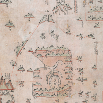
玉環營汛防輿圖
Map of Yuhuan Regiments| Hanyu Pinyin | Yuhuan ying xun fang yu tu |
|---|---|
| Date | After the 12th year of Qing Jiaqing's reign, 1807. |
| Measurement | |
| Techniques | Ink and color manuscript |
| Material | paper |
| Quantity | |
| Categories | |
| Country of Repository | |
| Identifier | British Library |
| Link to Original Database | http://explore.bl.uk/primo_library/... |
| Notes | Add. MS. 16359 ( E) |
| Share |
The title is missing; the title applied here is based on content. Scale and legend are not given; orientation is marked along west and south borders with north at the bottom. The map offers pictorial depictions of Yuhuan town and surrounding islands. Red lines form jurisdictional range for sub-prefectures and battalions. The map covers Yuhuan and surrounding islands with each island annotated and identified. Some islands are shown with caveats and warning notes. Based on the distribution of battalions, the map is believed to depict the Left and Right Battalions stationed in Yuhuan.
The map is similar to another map in the British Library’s collection titled “Map of Yuhuan Regiments” (Add. MS 16359 (F)). The two maps gives similar information. This map may have been drawn around the 12th year of Qing Jiaqing’s reign, 1807.
This map can be contrasted with the following maps in the National Palace Museum’s collection: Zhejiang Wenzhou Fu shu di li yu tu (map no. 020968); Zhejiang Wenzhou Fu shu di yu tu shuo (map no. 021312); Wenzhou Fu dao li tu (map no. 021496): Zhejiang quan sheng dao li zong tu (map no. 021505-021506); Zhejiang quan sheng tu (map no. 021589); and the Library of Congress collection: Zheijiang quan tu (gm 71005029); Zhejiang yan hai yao kou quan tu (gm 2002626763); Ning Jun di yu tu (gm 71002469); Qiantangjian yan an tu (gm 71005077); Jiang hai quan tu (gm 71005059).