Military and Traffic Maps
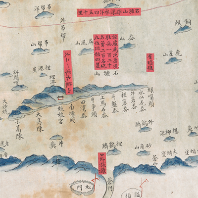
台州府太平縣海洋全圖
Coastal Map of Taiping County| Hanyu Pinyin | Taizhou Fu Taiping Xian hai yang quan tu |
|---|---|
| Date | Before the 15th year of Qing Jiaqing's reign, -1820. |
| Measurement | |
| Techniques | Ink and color manuscript |
| Material | paper |
| Quantity | |
| Categories | |
| Country of Repository | |
| Identifier | British Library |
| Link to Original Database | http://explore.bl.uk/primo_library/... |
| Notes | Add. MS. 16361 (A) |
| Share |
The map shows islands and coastal areas in Taiping County, Taizhou Prefecture. Scale, legend, and orientation are not given; but north is at the left, judging from locations on the map. The map looks like a partial element from a long scroll or a large map. The map offers pictorial depictions of cities, military posts, mountains, and islands. Red labels affixed to the map not only mark the coastal topography, but include troop staffing level. This is an official military map.
Cuhouke’ao Island and the area from Shahuomen to Dongzhengshan are marked. The area was under the jurisdiction of Taiping Regiment, according to the text on the right. The map may have been drawn before the 15th year of Jiaqing’s reign, 1820.
This map can be contrasted with the following maps in the National Palace Museum’s collection: Zhejiang Taizhou Fu shu di li yu tu (map no. 020967); Zhejiang Taizhou Fu di yu tu shuo (map no. 020130); Zhejiang quan sheng dao li zong tu (map no. 021505-021506); Zhejiang quan sheng tu (map no. 021589); and the Library of Congress collection: Zheijiang quan tu (gm 71005029); Zhejiang yan hai yao kou quan tu (gm 2002626763); Ning Jun di yu tu (gm 71002469); Qiantangjian yan an tu (gm 71005077); Jiang hai quan tu (gm 71005059).