Military and Traffic Maps
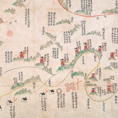
寧波府奉化縣洋圖
Coastal Map of Fenghua County| Hanyu Pinyin | Ningbo Fu Fenghua Xian yang tu |
|---|---|
| Date | Qing Daoguang period, 1821-1841. |
| Measurement | |
| Techniques | Ink and color manuscript |
| Material | paper |
| Quantity | |
| Categories | |
| Country of Repository | |
| Identifier | British Library |
| Link to Original Database | http://explore.bl.uk/primo_library/... |
| Notes | Maps 188.kk.1 (6) |
| Share |
Title is written on the verso of the map. Scale and legend are not given; orientation is noted on the bottom with south is at the top. The boundary of Ninghai and Fenghua Counties is noted at right; while the boundary of Dinghai and Yin County is noted on the left. This map focused on the military defense and deployment rather than the administrative divisions. Different symbols represent different levels of military units. The red arc on the upper right indicates the boundary of Fenghua and Ninghai; the red arc on the upper left indicates the boundary of Xiangshan and Fenghua Counties; the red line in the left marks the boundary of Dinghai and Fenghua Counties. Extensive annotations indicate the military posts’ adjustment.
The map focuses on military defense and is an official military map. It is almost identical in contents with the three “Military Map of Fenghua County” (Add. MS. 16359 (H), Maps 188.kk.1 (7), and Maps 188.kk.1 (8)) in the collection of British Library. This one seems made earliest of the four maps drawn during Daoguang period, 1821-1841.
This map can be studied with the following maps in the National Palace Museum’s collection: Zhejiang Ningbo Fu di yu tu shuo (map no. 020965); Zhejiang Ningbo Fu dao li tu (map no. 021491); Zhejiang Ningbo Fu shu di li yu tu (map no. 021510); Zhejiang Fujian yan hai hai fang tu (map no. 020869); and the Library of Congress collection: Zheijiang quan tu (gm 71005029); Zhejiang yan hai yao kou quan tu (gm 2002626763); Ning Jun di yu tu (gm 71002469); Qiantangjian yan an tu (gm 71005077); Jiang hai quan tu (gm 71005059).