Military and Traffic Maps
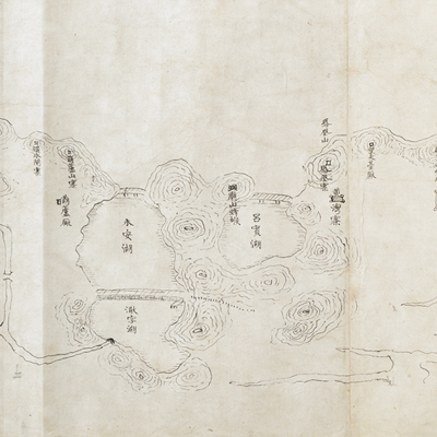
錢塘江河防圖
Qiantang River Fortifications Map| Hanyu Pinyin | Qiangtangjiang he fang tu |
|---|---|
| Date | Before the 20th year of Qing Daoguang's reign, -1840. |
| Measurement | |
| Techniques | Pen-and-ink manuscript |
| Material | paper |
| Quantity | |
| Categories | |
| Country of Repository | |
| Identifier | British Library |
| Link to Original Database | http://explore.bl.uk/primo_library/... |
| Notes | Add. MS. 16363 ( E) |
| Share |
No title appears on this map; the title applied here is based on content. Scale and legend are not given on the map. The map is drawn pictorially in ink. Orientation varies according to the river flow. The perspective is from north to south, since the Qiantang River and the north shore of the sea is depicted on the lower part of the map. The map covers the region from Xiaoshan County in Shaoxing Prefecture, the Qiantang River, and Hangzhou Bay to the east of Jinshan Wei in the southern Jiangsu Province; inland, the map extends to the area of Jiaxing, Xiushui, and Tongxiang County. The map locates piers, abutments, forts, military watchtowers, bridges, walled cities, and garrisons stationed along the river. This is an official deployment map of fortified strongholds along the river. Place names are indicated; government offices in Hangzhou town and islands around the Qiantang River are depicted.
Early Qing Wei-suo (guard post) is a military system that was inherited from the Ming Dynasty. For example, Jinshan Wei was established in the 20th year of Ming Hongwu’s reign, 1387. The map depicts the military garrison units established since the Ming Dynasty. The map may have been draw before the 20th year of Qing Daoguang’s reign, 1840.
This map can be contrasted with the following maps in the National Palace Museum’s collection: Zhejiang Ningbo Fu di yu tu shuo (map no.020965); Zhejiang Ningbo Fu dao li tu (map no.021491); Zhejiang Ningbo Fu shu di li yu tu (map no.021510); Zhejiang Fujian yan hai hai fang tu (map no.020869); Shimen Zhen bei di er zhan zhi Haining Xian Tangqi Zhen Daying dao li tu shuo (map no. 020819); Zhejiang Sheng hai tang tu (map no.020880); Zhejiang Shaoxing Fu shu di li yu tu (map no.020966); Zhejiang Shaoxing Fu di yu tu shuo (map no.021309); Zhejiang Shaoxing Fu dao li tu (map no.021492); Zhejiang Shaoxing Fu shu di tu (map no.021520); and the Library of Congress collection: Zheijiang quan tu (gm 71005029); Zhejiang yan hai yao kou quan tu (gm 2002626763); Ning Jun di yu tu (gm 71002469); Qiantangjian yan an tu (gm 71005077); Jiang hai quan tu (gm 71005059).