Military and Traffic Maps
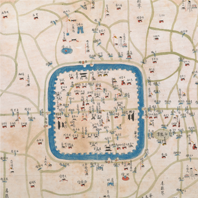
松江城守營汛輿圖
Military Map of Songjiang Garrison Brigade| Hanyu Pinyin | Songjiang Cheng shou ying xun yu tu |
|---|---|
| Date | The 20th-22nd year of Qing Daoguang's reign, 1840-1842. |
| Measurement | |
| Techniques | Ink and color manuscript |
| Material | paper |
| Quantity | |
| Categories | |
| Country of Repository | |
| Identifier | British Library |
| Link to Original Database | http://explore.bl.uk/primo_library/... |
| Notes | Add. MS. 16359 (O) |
| Share |
No title appears on this map; the title applied here is based on content. Scale and legend are not given; orientation is marked along the borders on all four sides with north at the bottom. The map depicts some features pictorially, including brigades, checkpoints pagodas, temples, bridge piers, government offices, colleges, flood control centers, and the granary of Lou, Fengxian, and Huatin Counties outside the west gate. Annotations are given on the map. Songjiang Garrison brigade was one of six brigades under the Jiangnan Corps Admiral. The Songjiang Garrison Brigade, Songjiang Prefecture, Huatin County and Lou County share the same capital town.
It is difficult to estimate when the map was made because there were few changes in the administrative names and locations during the Qing Dynasty. Compared with Songjiang Gazetteers during different periods, the map may have been drawn around the time of Opium War, 1840-1842.
This map can be contrasted with the following maps in the National Palace Museum’s collection: Jiangsu hai fang tu (map no. 021513); Baoshan Xian hai tang tu (Grand Council file no. 046243-a); Ge sheng yan hai kou ai quan tu (map no. 020867); Yan hai chang tu (map no. 020868); Jiangnan ge dao fu tu biao cun (map no. 020923-020941); and the Library of Congress collection: Jiang hai quan tu (gm 71005059); Qi sheng yan hai quan tu (gm 71005064); Hai jiang yang jie xing shi tu (gm 71005021); Nan bei yang he tu (gm 71005215); Sonan hai tang tu (gm 71005013).