Military and Traffic Maps
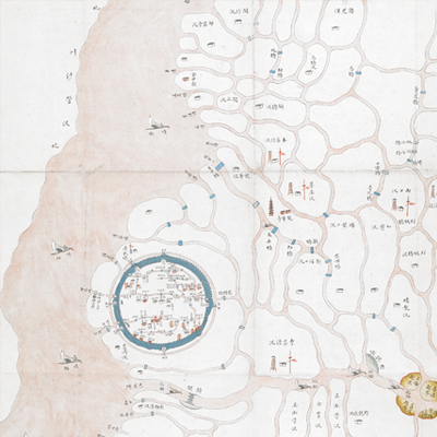
上海縣水道營汛圖
Hydrographic and Battalion Map of Shanghai County| Hanyu Pinyin | Shanghai Xian shui dao ying xun tu |
|---|---|
| Date | The ninth year of Qing Tongzhi's reign, 1870. |
| Measurement | |
| Techniques | Ink and color manuscript |
| Material | paper |
| Quantity | |
| Categories | |
| Country of Repository | |
| Identifier | British Library |
| Notes | Or. 15261.c.3/2 |
| Share |
Scale and legend are not given; orientation is marked along the borders on all four sides with north at the bottom. The map offers pictorial depictions of cities, government offices, colleges, military posts, and ferries. The map covers crisscrossing waterways and flood areas in Shanghai. Patrol boats are shown on the Wusong River, which originates from Taihu (Tai Lake) and merges with other branches to enter Yangtze River.
The governor Zeng Guofan petitioned to replace the navy river defense system with three branches in the seventh year of Tongzhi’s reign, 1868. The distribution of military posts resembles the information given in the official Shanghai Gazetteers in 1871; the map may have been made around this period.
This map can be contrasted with the following maps in the National Palace Museum’s collection: Jiangsu hai fang tu (map no. 021513); Baoshan Xian hai tang tu (grand council file no. 046243-a); Ge sheng yan hai kou ai quan tu (map no. 020867); Yan hai an chang tu (map no. 020868); Jiangnan ge dao fu tu biao cun (map no. 020923-020941); and the Library of Congress collection: Jiangsu quan tu (gm 71005111); Changjiang shui shi Guazhou Zhen Biaozhong Ying jiang xu quan tu (gm 80692824); Menghe Ying hui cheng Bei Ying xun jing jiang cheng li shu jie zhi tu (gm 80692825).