Military and Traffic Maps
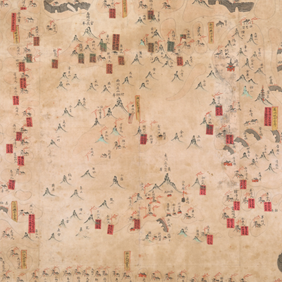
太湖營汛輿圖
Military Map of Taihu Brigade| Hanyu Pinyin | Taihu Ying xun yu tu |
|---|---|
| Date | Around the 20th year of Qing Daoguang's reign, 1840. |
| Measurement | |
| Techniques | Ink and color manuscript |
| Material | paper |
| Quantity | |
| Categories | |
| Country of Repository | |
| Identifier | British Library |
| Link to Original Database | http://explore.bl.uk/primo_library/... |
| Notes | Add. MS. 16358 ( C) |
| Share |
No title appears on this map; the title applied here is based on content. Scale and legend are not given; orientation is marked along the borders on all four sides with north at the top. Tai Lake is in the center of the map. The map pictorially depicts brigades and the capital towns of Changzhou Prefecture, Wuxi County, Suzhou Prefecture, Wujiang County, Huzhou Prefecture, Changxing County, Yixing County, and the Taihu Navy. All brigades and bridge piers are annotated; 10 red labels affixed to the map indicate the number of soldiers at each post.
East Dongting Mountain is annotated as “Taihu Sub-prefecture,” that was established in the first year of Qing Qianlong’s reign, 1736 and relocated to the east of the Dongting Mountain the next year, 1737. Taihu Brigade governed Junction region of Zhejiang and Jiangsu provinces, and was also under the jurisdiction of Zhejiang Corps Admiral. The map may have been drawn around the 20th year of Qing Daoguang’s reign, 1840.
This map can be contrasted with the following maps in the National Palace Museum’s collection: Jiangsu hai fang tu (map no. 021513); Baoshan Xian hai tang tu (Grand Council file no. 046243-a); Ge sheng yan hai kou ai quan tu (map no. 020867); Yan hai chang tu (map no.020868); Jiangnan ge dao fu tu biao cun (map no. 020923-020941); and the Library of Congress collection: Jiangsu quan tu (gm 71005111); Changjiang shui shi Guazhou Zhen Biaozhong Ying jiang xu quan tu (gm 80692824); Menghe Ying hui cheng Bei Ying xun jing jiang cheng li shu jie zhi tu (gm 80692825).