Military and Traffic Maps
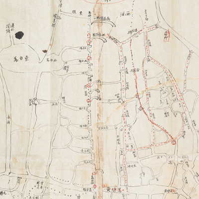
蘇州城北河道圖
Map of Northern Suburbs Waterways of Suzhou| Hanyu Pinyin | Suzhou cheng bei he dao tu |
|---|---|
| Date | Around the second year of Qing Tongzhi's reign, 1863. |
| Measurement | |
| Techniques | Pen-and-ink manuscript |
| Material | paper |
| Quantity | |
| Categories | |
| Country of Repository | |
| Identifier | British Library |
| Notes | Or. 2338 (32) 21 |
| Share |
No title appears on the map; the title applied here is based on content. This is a distribution map of the waterways outside the north gate of Suzhou Prefecture. No scale or legend is given; orientation is marked along the borders on all four sides with north at the bottom. The map starts from west at Tai Lake and ends in the east at Yangcheng Lake; the border of Wuxi forms the northern boundary and ends to the south at Qi gate of the Suzhou Prefecture. The map is annotated in red pen with the marching routes and the names of “Victory Camp” and “King’s Army Camp Eight.” This was most likely used as a military operational map.
This is one of Charles George Gordon’s No. 32 collection. In 1863, he led his army against Kunshan, which was captured at considerable loss. Gordon then took his force through the country, seizing towns until, with the aid of Imperial troops, the Suzhou town was captured. The map may have been drawn during the 1860s.
This map can be contrasted with the following maps in the National Palace Museum’s collection: Changjiang di li tu (map no. 020878); Changjiang tu (map no. 020879); Jiangnan ge dao fu tu biao cun (map no. 020923-020941); Jiangnan quan sheng dao li zong tu (map no. 021560); Jiangsu hai fang tu (map no. 021513)and Ping ding yue fei zhan tu san shi jiu zhang (map no. 021283.001-021294.002); and the Library of Congress collection: Jiangsu quan tu (gm 71005111); Changjiang shui shi Guazhou Zhen Biaozhong Ying jiang xu quan tu (gm 80692824); Qing jun wei gong Jinling Cheng tu (gm 71005033).