Military and Traffic Maps
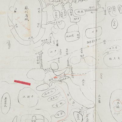
蘇州府境輿圖
Map of Suzhou Prefecture| Hanyu Pinyin | Suzhou Fu jing yu tu |
|---|---|
| Date | Between Qing Xianfeng and early Tongzhi period, 1855-1864. |
| Measurement | |
| Techniques | Pen-and-ink manuscript on paper |
| Material | paper |
| Quantity | |
| Categories | |
| Country of Repository | |
| Identifier | British Library |
| Notes | Or. 2338 (32) 3 |
| Share |
No title appears on the map; the title applied here is based on content. No scale or legend is given; orientation is marked along the borders on all four sides with north at the top. The map is drawn in pen-and-ink with the town walls briefly sketched pictorially. The map covers territory of Kunshan and Xinyang Counties in the east of Suzhou, and Wujiang and Zhenze Counties in the south of Suzhou. Red label pasted on the map near Tai Lake recorded: “Be aware of underwater piers.” All bridges, checkpoints, and rivers are identified with annotations. Although place names are given, there is not enough information to reach the exact date the map was made. However, since this map is one of Charles George Gordon’s No. 32 collection, it may have been drawn around the period of Xianfeng and Tongzhi, 1850s.
This map can be studied with the following maps in the National Palace Museum’s collection: Changjiang di li tu (map no. 020878); Changjiang tu (map no. 020879); Jiangnan ge dao fu tu biao cun (map no. 020923-020941); Jiangnan quan sheng dao li zong tu (map no. 021560); Jiangsu hai fang tu (map no. 021513)and Ping ding yue fei zhan tu san shi jiu zhang (map no. 021283.001-021294.002); and the Library of Congress collection: Jiangsu quan tu (gm 71005111); Changjiang shui shi Guazhou Zhen Biaozhong Ying jiang xu quan tu (gm 80692824); Qing jun wei gong Jinling Cheng tu (gm 71005033).
This map can be studied with the following maps in the National Palace Museum’s collection: Changjiang di li tu (map no. 020878); Changjiang tu (map no. 020879); Jiangnan ge dao fu tu biao cun (map no. 020923-020941); Jiangnan quan sheng dao li zong tu (map no. 021560); Jiangsu hai fang tu (map no. 021513)and Ping ding yue fei zhan tu san shi jiu zhang (map no. 021283.001-021294.002); and the Library of Congress collection: Jiangsu quan tu (gm 71005111); Changjiang shui shi Guazhou Zhen Biaozhong Ying jiang xu quan tu (gm 80692824); Qing jun wei gong Jinling Cheng tu (gm 71005033).