Military and Traffic Maps
太倉州沿江水勢港口營汛分界圖
Military Map of Taicang Municipality| Hanyu Pinyin | Tiacang Zhou yan jiang shui shi gang kou ying xun fen jie tu |
|---|---|
| Date | After the 12th year of Qing Jiaqing's reign, 1807-. |
| Measurement | |
| Techniques | Ink and color manuscript |
| Material | paper |
| Quantity | |
| Categories | |
| Country of Repository | |
| Identifier | British Library |
| Link to Original Database | http://explore.bl.uk/primo_library/... |
| Notes | Add. MS. 16361 (N) |
| Share |
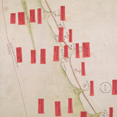
No title appears on this map; the title applied here is based on content. Scale and legend are not given; orientation and boundaries are marked along the borders on all four sides with north at the bottom. The map depicts some features with simple images and annotations, including piers, military posts, artillery forts, and town walls. There are 22 red labels with written text affixed to the map to note the depths along the Yangtze River including the midline, flood, and river width, land piers, and mileage between military posts to Liuhe Fort. The map only illustrates Taicang town and Qianjing town. This is a seacoast defense map, a typical official military map.
Taicang Municipality was established in 1724, with four counties; its attached county was Zhenyang County. Qianjing town was established in 1738. There is a red label next to Qianjing town noting the distance mileage information. From then on, Liuhe Brigade was endorsed as a leader. The map may have been drawn around the 12th year of Qing Jiaqing’s reign, 1807.
This map can be studied with the following maps in the National Palace Museum’s collection: Ge sheng yan hai kou ai quan tu (map no. 020867); Yan hai an chang tu (map no. 02068); Changjiang di li tu (map no. 020878); Changjiang tu (map no. 20879); Jiangsu hai fang tu (map no. 021513); and the Library of Congress collection: Jiang hai quan tu (gm 71005059); Qi sheng yan hai quan tu (gm 71005064); Hai jiang yang jie xing shi tu (gm 71005021); Nan bei yang he tu (gm 71005215); Sonan hai tang tu (gm 71005013).