Military and Traffic Maps
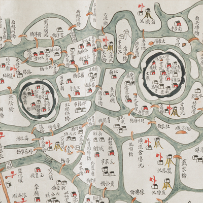
劉河營輿圖
Military Map of Liuhe Brigade| Hanyu Pinyin | Liuhe Ying yu tu |
|---|---|
| Date | The 18th year of Qing Qianlong's reign, 1753. |
| Measurement | |
| Techniques | Ink and color manuscript |
| Material | paper |
| Quantity | |
| Categories | |
| Country of Repository | |
| Identifier | British Library |
| Link to Original Database | http://explore.bl.uk/primo_library/... |
| Notes | Add. MS. 16362 ( E) |
| Share |
Title is written on a label in black ink and affixed to the map. Scale and legend are not given; orientation is marked along neighboring county boundaries with north at the bottom. The map covers the area bordered by Wusong Brigade to the south, Suzhou Brigade to the west, Fushan Brigade to the north and the sea and the Qibing Brigade in Chongming County to the east. The map offers pictorial depictions of military posts, piers, cities, government offices, bridges, and settlements. All place names are annotated. The map is folded with pictorial depictions at the left and text on the right. The annotation clearly describes the evolution of the Liuhe region from the 18th year of Ming Chenghua’s reign, 1482 to the 18th year of Qing Qianlong’s reign, 1753. The information given on the map depicts the Liuhe region before the 18th year of Qing Qianlong’s reign, 1753. The map may have been made then.
This map can be contrasted with the following maps in the National Palace Museum’s collection: Ge sheng yan hai kou ai quan tu (map no. 020867); Yan hai an chang tu (map no. 020867); Changjiang di li tu (map no. 020878); Changjiang tu (map no. 020879); Jiangsu hai fang tu (map no. 021513); and the Library of Congress collection: Jiang hai quan tu (gm 71005059); Qi sheng yan hai quan tu (gm 71005064); Hai jiang yang jie xing shi tu (gm 71005021); Nan bei yang he tu (gm 71005215); Sonan hai tang tu (gm 71005013).
This map can be contrasted with the following maps in the National Palace Museum’s collection: Ge sheng yan hai kou ai quan tu (map no. 020867); Yan hai an chang tu (map no. 020867); Changjiang di li tu (map no. 020878); Changjiang tu (map no. 020879); Jiangsu hai fang tu (map no. 021513); and the Library of Congress collection: Jiang hai quan tu (gm 71005059); Qi sheng yan hai quan tu (gm 71005064); Hai jiang yang jie xing shi tu (gm 71005021); Nan bei yang he tu (gm 71005215); Sonan hai tang tu (gm 71005013).