Military and Traffic Maps
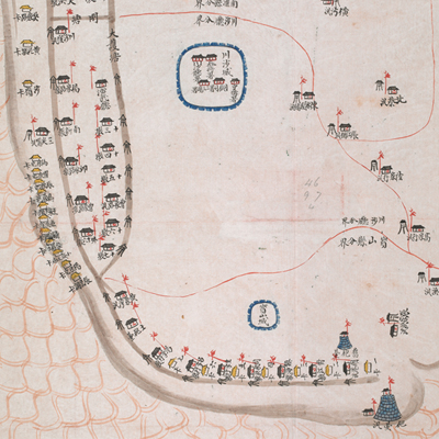
川沙營營汛輿圖
Military Map of Chuansha Brigade| Hanyu Pinyin | Chuansha Ying ying xun yu tu |
|---|---|
| Date | After the fifth year of Qing Daoguang's reign, 1825. |
| Measurement | |
| Techniques | Ink and color manuscript |
| Material | paper |
| Quantity | |
| Categories | |
| Country of Repository | |
| Identifier | British Library |
| Link to Original Database | http://explore.bl.uk/primo_library/... |
| Notes | Add. MS. 16358 (P) |
| Share |
No title appears on this map; the title applied here is based on content. Scale and legend are not given; orientation is marked along the borders on all four sides with north at the bottom. The map depicts military checkpoints, brigades, cities and towns pictorially. The sea is depicted with fish-scale patterns. Place names are identified. The red written label on the top of the map explains the range and jurisdiction of Chuansha Brigade. In the ninth year of Tongzhi’s reign, 1870, Chuansha Brigade was reclassified under the jurisdiction of the Wusong Brigade, a naval unit.
Chuansha Brigade located inside the Chuansha sub-prefecture, governed battalions of Chuansha, Shanghai, Nanhui, and Baoshan. Administratively they were all under the Songjiang Prefecture and Taicang Municipality. The map may have been drawn after the fifth year of Qing Daoguang’s reign, 1825.
This map can be contrasted with the following maps in the National Palace Museum’s collection: Jiangsu hai fang tu (map no. 021513); Baoshan Xian hai tang tu (grand council file no. 046243-a); Ge sheng yan hai kou ai quan tu (map no. 020867); Yan hai an chang tu (map no. 020868); Jiangnan ge dao fu tu biao cun (map no. 020923-020941); Zhaowen Xian Baimao Xuliujing er he ni qing tiao jun tu (Grand Council file no. 012168); and the Library of Congress collection: Jiang hai quan tu (gm 71005059); Qi sheng yan hai quan tu (gm 71005064); Hai jiang yang jie xing shi tu (gm 71005021); Nan bei yang he tu (gm 71005215); Sonan hai tang tu (gm 71005013).