Military and Traffic Maps
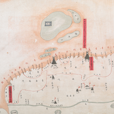
海門廳各港水勢深淺全圖
Map of Measuring the Depth of Water Potential of Each Port in Haimen Sub-prefecture| Hanyu Pinyin | Haimen Ting ge gnag shui shi shen qian quan tu |
|---|---|
| Date | 清道光20年至22年(1840-1842) |
| Measurement | |
| Techniques | Ink and color manuscript |
| Material | paper |
| Quantity | |
| Categories | |
| Country of Repository | |
| Identifier | British Library |
| Link to Original Database | http://explore.bl.uk/primo_library/... |
| Notes | Add. MS. 16359 (P) |
| Share |
No title appears on this map; the title applied here is based on content. Scale and legend are not given; orientation are marked along the borders on all four sides with north at the bottom. The map depicts some features of Haimen sub-prefecture with simple images, including military units. Watch towers of Yujiao Port and Yueyu Port are deliberately enlarged, highlighting the nature and functionality of the map.
Red labels with written text are affixed to the map to record mileage and coastal water levels, including water depth at high and low tides. An official seal of Haimen is stamped over the top of the map in both Chinese and Manchu languages. This map is a typical official military map. This is part of a set with another map in the British Library titled “Military Map of Haimen Sub-prefecture” (Add. MS. 16359 (Q)), but the cartographic contents are slightly different. Both maps may have been drawn around the 20th to the 22nd year of Qing Daoguang’s reign, 1840-1842.
This map can be contrasted with the following maps in the National Palace Museum’s collection: Jiangnan tong sheng fu zhou xian yu di tu shuo (map no. 021297); Zhang kan Tongzhou Chongming Zhaowen san zhou xian sha di zong tu (map no. 021428); Jiangsu hai fang tu (map no. 021513); and the Library of Congress collection: Jiang hai quan tu (gm 71005059); Qi sheng yan hai quan tu (gm 71005064); Hai jiang yang jie xing shi tu (gm 71005021); Nan bei yang he tu (gm 71005215); Beiyang fen tu (gm 71005226); Huanghe nan he tu (gm 71005024).