Military and Traffic Maps
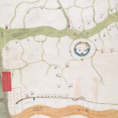
阜寧縣廟灣營界會勘圖
Survey Map of Funing County, Miaowan Brigade| Hanyu Pinyin | Funing Xian Miaowan Ying jie hui kan tu |
|---|---|
| Date | Around the 24th year of Qing Qianlong's reign, 1759. |
| Measurement | |
| Techniques | Ink and color manuscript |
| Material | paper |
| Quantity | |
| Categories | |
| Country of Repository | |
| Identifier | British Library |
| Link to Original Database | http://explore.bl.uk/primo_library/... |
| Notes | Add. MS. 16359 (M) |
| Share |
Title appears to be missing from the map; the title applied here is based on content. Scale and legend are not given; orientation is marked along the borders on all four sides with north at the bottom. The map depicts some features pictorially, such as fortification works, villages, temples, and town walls. Most place names are annotated on the map; red labels are affixed to the map to note the three areas of Miaowan Brigade (Sheyang Lake, Shuangyangzi Port, the mouth of the Yellow River), coastline sea rise, tides and water level changes, and coastal sand lines surveys. Based on the depiction of battalions and river branches along Sheyang Lake, the map may have been drawn around the 24th year of Qianlong’s reign, 1759.
This map can be contrasted with the following maps in the National Palace Museum’s collection: Huang Huai he tu (map no. 020874); Huaihe tu (map no. 020875-020876); Huaihe liu yu tu (map no. 021486); Huanghe Huaihe liu yu tu (map no. 021566); and the Library of Congress collection: Jiang hai quan tu (gm 71005059); Qi sheng yan hai quan tu (gm 71005064); Hai jiang yang jie xing shi tu (gm 71005021); Nan bei yang he tu (gm 71005215); Beiyang fen tu (gm 71005226).
This map can be contrasted with the following maps in the National Palace Museum’s collection: Huang Huai he tu (map no. 020874); Huaihe tu (map no. 020875-020876); Huaihe liu yu tu (map no. 021486); Huanghe Huaihe liu yu tu (map no. 021566); and the Library of Congress collection: Jiang hai quan tu (gm 71005059); Qi sheng yan hai quan tu (gm 71005064); Hai jiang yang jie xing shi tu (gm 71005021); Nan bei yang he tu (gm 71005215); Beiyang fen tu (gm 71005226).