Flood Control and Embankment Maps
浙江省城水利全圖
Water Conservation Map of Hangzhou| Hanyu Pinyin | Zhejiang Sheng cheng shui li quan tu |
|---|---|
| Creator | Ruan Yuan (1764-1849) |
| Date | The ninth year of Qing Jiaqing's reign, 1804. |
| Measurement | |
| Techniques | Stone carving, ink on paper |
| Material | paper |
| Quantity | |
| Categories | |
| Country of Repository | |
| Identifier | British Library |
| Link to Original Database | http://explore.bl.uk/primo_library/... |
| Notes | Maps Tab.1.d.3 |
| Share |
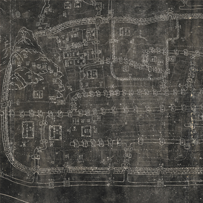
The title is written on the upper left. Scale, legend, and orientation are not given. However, north is at the top, judging from locations on the map. This stone-rubbing map appears rather dark. Most features are indicated by graphic lines, but the rich content presents a wealth of information. Hangzhou town walls, palaces, government offices, warehouses, colleges, arches, temples, ferries, and piers are annotated and shown pictorially. The West Lake and the Qiantang River are identified and only depicted in simple lines. The Wu Mountains, temples, and colleges outside the city are depicted pictorially. The map is covered with bridge piers, but mainly focused on the waterways in Hangzhou. After comparing the stone rubbing and Ruan Yuan’s other works, the map may have been drawn in the ninth year of Qing Jiaqing’s reign, 1804.
This map can be contrasted with the following maps in the National Palace Museum’s collection: Zhejiang Sheng hai tang tu (map no. 020880); Jingkou yi xia Xiyang Yunhe yi dai he hu zhi Hangzhou qing xing (map no. 020881); Zhejiang Hangzhou Fu shu di li yu tu (map no. 020962); Hangzhou tu (map no. 021484); Zhejiang Qiantang Jiang shui lu tu (Grand Council file no. 033184); and the Library of Congress collection: Anlanyuan zhi Jianshan qi zuo dao li tu shuo (gm 85693767); Anlanyuan zhi Hangzhou Fu xing gong dao li tu shuo (gm 2002626740); Zhejiang Sheng yuan fang xiang quan tu (gm 71005032); Zhejiang Sheng yuan shui li quan tu (gm 89691149); Qiantangjian yan an tu (gm 71005077).
This map can be contrasted with the following maps in the National Palace Museum’s collection: Zhejiang Sheng hai tang tu (map no. 020880); Jingkou yi xia Xiyang Yunhe yi dai he hu zhi Hangzhou qing xing (map no. 020881); Zhejiang Hangzhou Fu shu di li yu tu (map no. 020962); Hangzhou tu (map no. 021484); Zhejiang Qiantang Jiang shui lu tu (Grand Council file no. 033184); and the Library of Congress collection: Anlanyuan zhi Jianshan qi zuo dao li tu shuo (gm 85693767); Anlanyuan zhi Hangzhou Fu xing gong dao li tu shuo (gm 2002626740); Zhejiang Sheng yuan fang xiang quan tu (gm 71005032); Zhejiang Sheng yuan shui li quan tu (gm 89691149); Qiantangjian yan an tu (gm 71005077).