Flood Control and Embankment Maps
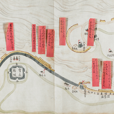
寶山海塘工程全圖
Map of the Embankment Project in Baoshan County| Hanyu Pinyin | Baoshan hai tang gong cheng quan tu |
|---|---|
| Date | After the 15th year of Qing Daoguang's reign, 1835-. |
| Measurement | |
| Techniques | Ink and color manuscript |
| Material | paper |
| Quantity | |
| Categories | |
| Country of Repository | |
| Identifier | British Library |
| Link to Original Database | http://explore.bl.uk/primo_library/... |
| Notes | Add. MS. 16362 (D) |
| Share |
The map depicts an embankment project in Baoshan County along the Yangtze River. No scale or legend is given; orientation varies according to the flow of water and force of river current. In most cases, north is at the left. Baoshan County was originally under the jurisdiction of Suzhou Prefecture in Jiangsu Province. In 1724, Baoshan became one of the four administrative divisions under Taicang Municipality. Baoshan County was in the area south of Zhenyang County, north and east of Shanghai; it is about one li to the sea in the northeast, and 100 li to the coastal area of Chongming County. The map shows only the area along the river from the border of Zhenyang County to Haungsha Bay on the border of Shanghai. The map depicts the Yangtze River, flood control stations, artillery forts, cities, and sluice gates. Every embankment project is identified with red labels affixed to the map illustrating the measurement for embankment stones.
The embankment was the northern section of the Qing Dynasty’s Jiangnan seawall project. It started from a major flood disaster in the 10th year of Yongzheng’s reign, 1732. The map may have been drawn after the 15th year of Daoguang’s reign, 1835.
This map can be contrasted with the following maps in the National Palace Museum’s collection: Jiangsu hai fang tu (map no. 021513); Baoshan Xian hai tang tu (Grand council file no. 046243-a); Jiang Zhe hai tang tu shi gong cheng qing xing tu (Grand Council file no. 012603); and the Library of Congress collection: Su nan hai tang tu (gm 71005013); Jiang hai quan tu (gm 71005059).

