Flood Control and Embankment Maps
淮揚水道圖
Map of the Waterways in the Northern Jiangsu Province| Hanyu Pinyin | Huai Yang shui dao tu |
|---|---|
| Date | The 12th -14th year of Qing Jiaqing's reign, 1807-1809. |
| Measurement | |
| Techniques | Ink and color manuscript |
| Material | paper |
| Quantity | |
| Categories | |
| Country of Repository | |
| Identifier | British Library |
| Notes | Or. 13145 |
| Share |
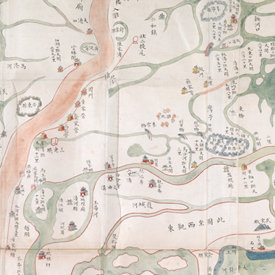
No title appears on this map; the title applied here is based on content. No scale or legend is given; orientation appears along the four borders with north at the left. The map covers the area between the Yangtze River from Yizheng to Zhenjiang and the Yellow River (now called scrap Yellow River) from Xuzhou to the estuary. The Grand Canal winds through the whole map, from Taizhou, Yancheng to the mouth of the Yellow River in the east, and Mengcheng, Xuzhou and Luoma Lake area in the West. It is the area between the north of Yangtze River in Jiangsu and northeastern Anhui. The map also covers Hongze Lake, the Grand Canal and its fortifications.
Although there is no expressed legend on the map, different levels of administrative divisions, such as prefecture, municipality, and county are represented by pictorial town walls; a few important ones use bigger town walls. Other related government offices, temples, embankments, fascine dams, and flood camps use house symbols; houses with flags are defensive garrison stations. Distances to Daguan are annotated in various places on the map; Daguan refers to Huai’an Daguan indicating tax collection offices (see: Deng Yi-bing, “The Establishment of Customs Duties in the Early Qing,” Studies in Qing History, 2007, 0(2).) There are many changes made in the 100 li long river engineering projects as illustrated from Wujiantun to Jiangjiaba on the east of Hongze Lake (see: National Palace Museum document no. 404008426). High embankments are represented by enlarged icons with masonry annotations. Different types of levees are indicated by different symbols. A few place names are annotated in English.
Throughout history, many levees and embankments were built on the Yellow River, the Grand Canal, and Hongze Lake, indicating serious flooding. Each project reflects different historical construction methods. The map shows the repair work needed to be done near the north of the high embankments. The map may have been drawn during the 12th and the 14th year of Qing Jiaqing’s reign, 1807-1809.
This map can be contrasted with the following maps in the National Palace Museum’s collection: Jiangsu Nanhe tu (map no. 021501); Huanghe tu (map no. 020870, 020872, 020877); Jiangnan Sheng Yunhe ge ting shu he dao zha ba gong cheng qing xing tu (map no. 020911); Jiangnan Yunhe di shao zha ba gong cheng zong tu (map no. 020913); Jiangnan Honghe yi dai qing xing tu (Grand council document no. 045112-a); Taozhuang xin he xing shi tu (Grand Council document no. 040792); Huanghe Qinghe mu long tu (Grand Council document no. 005027a-005027c); Taozhuang xin he tu (Grand Council document no, 040555-a); and the Library of Congress collection: Henan Sheng quan tu (gm 71002471); Tongwaxiang yi ixia Huanghe chuan yun di gong tu tie shou (gm 71002482); Tongwaxiang zhi hai kuo xin Huanghe dao di gong xing shi tu (gm 71002473).