Flood Control and Embankment Maps
運河圖
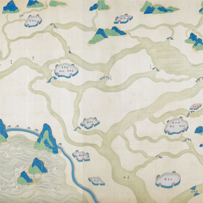
Map of the Grand Canal| Hanyu Pinyin | Yunhe tu |
|---|---|
| Date | Around the 41st year of Qing Kangxi's reign, 1702. |
| Measurement | |
| Techniques | Ink and color manuscript |
| Material | silk |
| Quantity | |
| Categories | |
| Country of Repository | |
| Identifier | British Library |
| Notes | Or. 2362 |
| Share |
The map expands from right to left. The map starts from the right at Beijing to the left at the Qiantang River and Hangzhou Bay. The map shows the entire length of the Beijing-Hangzhou Grand Canal in history. No scale or legend is given. Orientation is not fixed, but the left bank is always at the top moving northward. Drawn in traditional Chinese landscape style, the map depicts the geographic and cultural features along the canal, including administrative divisions, rivers, waterway engineering projects, embankment dams, culvert gates, sluice gates, bridges, and mountains. At the intersection of the Yellow River, the Yangtze River and the Grand Canal’s river engineering project is described in detail with annotations. Rivers are marked with different colors: the Yangtze is depicted in dark green with white currents, the Yellow River is depicted like a yellow dragon; canals and other rivers are indicated in grass green; mountains in bluish green. Annotations describe river fortification projects and the source and branches of the Yellow River and the Grand Canal.
Explanation given on the river construction projects is another distinctive feature of the map. Most explanatory texts are comments on the river projects during mid-Kangxi period. The map may have been drawn around the 41st of Kangxi’s reign, 1702.
This map can be contrasted with the following maps in the National Palace Museum’s collection: Huang Yunhe gong cheng tu (map no. 020891-020910); Ba sheng Yunhe quan yuan shui li qing xing tu yi ce (map no. 020912); Jiangnan Yunhe di shao zha ba gong cheng zong tu (map no. 020913); Shangdong Yunhe tu (map no. 021588); Huang he tu shuo (map no. 021425-021426); Li dai Huang he yi xi tu (map no. 021427); Huang he tu (map no. 021500); Huang he tu (map no. 021556); Huang he tu (map no. 021557-021558); Huang he tu (map no. 021559); and the Library of Congress collection: Shandong tong sheng Yunhe qing xing quan tu (gm 80692829); Shandong Yunhe quan tu (gm 71005023); Quan cao yun dao tu (gm 71005057); Huang Yun Hu He quan tu (gm 71005017).