Maps of Temples, Palaces and Royal Gardens
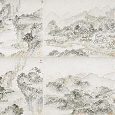
武夷山十八景圖
Eighteen Landscape of the Wuyi Mountains| Hanyu Pinyin | Wuyi Shan shi ba jing tu |
|---|---|
| Date | Between the 57th year of Qing Kangxi's reign and the 16th year of Qianlong's reign, 1718-1751. |
| Measurement | |
| Techniques | Ink and color manuscript |
| Material | paper |
| Quantity | |
| Categories | |
| Country of Repository | |
| Identifier | British Library |
| Notes | Or. 2342 A |
| Share |
No title appears on this map; the title applied here is based on content. The Wuyi Mountains are located in Jianning Prefecture of Fujian Province. The Wuyi mountain range has a total area of 120 li, and ranges from Chong River in the east to Jiangcunli in the west; from Huanglong river in the north to Lanyan in the south. It is surrounded by ravines and not connected with other mountains. The map was drawn in typical Chinese landscape style with some features shown pictorially. The map depicts rocks, ravines, streams, bridges, villages, colleges, temples, tea gardens, docks, boats, ferries and the capital town of Jianning Prefecture, Chong’an County of Fujian Province, Guangxin Prefecture and Qianshan County of Jiangxi Province. The map renders a vivid depiction of dynamic and static images.
All geographic features are annotated and the entire map was well done with attention to minute detail. However, there is no indication of authorship, so it is difficult to know exactly when the map was created. We can safely give a range of years based on the names of temples and ferries on the map; the map was drawn between the 57th year of Qing Kangxi’s reign and the 16th year of Qianlong’s reign, 1718-1751.
This map can be contrasted with the following maps in the National Palace Museum’s collection: Fujian Sheng di tu (map no. 021476); Jiangxi Guangxin Fu shu qi xian di yu tu (map no. 021534); and the Library of Congress collection: Fujian quan tu (gm 96685903); Fu Sheng quan tu (gm 71002477); Quanzhou Fu yu di tu shou (gm 202626790).