Maps of Temples, Palaces and Royal Gardens
武夷山九曲溪全圖
Landscape of the Jiuqu River in the Wuyi Mountains| Hanyu Pinyin | Wuyi Shan Jiuquxi quan tu |
|---|---|
| Date | Between the 57th year of Qing Kangxi's reign and the 16th year of Qianlong's reign, 1718-1751. |
| Measurement | |
| Techniques | Ink and color manuscript |
| Material | silk |
| Quantity | |
| Categories | |
| Country of Repository | |
| Identifier | British Library |
| Link to Original Database | http://explore.bl.uk/primo_library/... |
| Notes | Maps S.T.K.371 |
| Share |
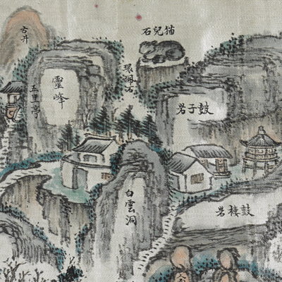
The title applied here is based on content. The map was drawn in traditional pictorial mapping style to depict the natural and cultural landscape of the Jiuqu River and the Wuyi Mountain area. The map isn’t consistent with actual orientation. Jiuqu River is located in southern Chong’an County; it originates from the Sanbao Mountain, and is the origin of South River. The perfect combination of mountain and water is the most prominent feature in Jiuqu River Valley. The Wuyi Mountains is located in the junction of Jiangxi and Fujian provinces. The map shows overlapped peaks, rocks, watchtowers, stone steps, temples, colleges, bridge piers, boat rides, and visitors. The whole map transcends ordinary scenery but brings out magnificent serenity and vivid charm.
Judging from information on the map, it is similar to the other map in the British Library’s collection titled “Eighteen Landscape of the Wuyi Mountains” (Or. 2342 A). Both maps depict scenery and historical buildings along the way to the Jiuquxi River in the Wuyi Mountains; “Eighteen Landscape of the Wuyi Mountains” was drawn in the graceful and meticulous style associated with Northern style painting; the “Landscape of the Jiuqu River in the Wuyi Mountains” used the Southern impressionistic style based on thick pen strokes.
This map can be contrasted with the following maps in the National Palace Museum’s collection: Fujian Sheng di tu (map no. 021476); Jiangxi Guangxin Fu shu qi xian di yu tu (map no. 021534); and the Library of Congress collection: Fujian quan tu (gm 96685903); Fu Sheng quan tu (gm 71002477); Quanzhou Fu yu di tu shou (gm 202626790).

