Maps of Temples, Palaces and Royal Gardens
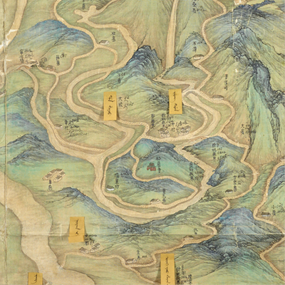
四明山圖
Map of the Siming Mountains| Hanyu Pinyin | Siming Shan tu |
|---|---|
| Date | After the 45th year of Qing Qianlong's reign, 1780-. |
| Measurement | |
| Techniques | Ink and color manuscript |
| Material | silk |
| Quantity | |
| Categories | |
| Country of Repository | |
| Identifier | British Library |
| Link to Original Database | http://explore.bl.uk/primo_library/... |
| Notes | Maps S.T.Z.445 |
| Share |
The map depicts the geographic features of the Siming Mountains. There is no expressed scale or legend. Orientations are noted along the four borders of the map with north at the bottom. The Siming Mountain is also known as Juyu Mountain. It is situated about 150 li southwest of Yin County. The map covers the surrounding territory and counties of the Siming Mountain, including Shangyu and Yuyao Counties in Shaoxing Prefecture, and Fenghua and Cixi Counties in Ningpo Prefecture.
The map applied the Chinese stylized brush expressions of shade and texture known as Cunfa to depict the majestic three-dimensional image of the Siming Mountains, rivers, and the winding mountain roads that are indicated with dotted lines. The Yao River and the Cao’e River are the two main rivers. Place names are all annotated in Chinese: yellow labels affixed next to the place names are written in Manchu; and the Russian names were penciled in on the map, obviously at a later time.
There was little information on the map to indicate when the map was made. However, the Lower Dam, which was the major road connecting Ningbo and Shaoxing of Zhejiang Province appeared on the map. The Lower Dam, also known as the Lower New Dam, was built in the 45th year of Qiangling’s reign, 1780, according to Guangxu Yuyao Local Gazetteers. Based on this information alone, the map may have been drawn after 1780.
This map can be contrasted with the following maps in the National Palace Museum’s collection: Zhejiang quan Sheng tu (map no. 021589); Zhejiang Ningbo Fu di yu tu shuo (map no. 020965); Zhejiang Ningbo Fu shu di li yu tu (map no. 021510); Zhejiang Shaoxing yu fu shu di li yu tu (map no. 020966); Zhejiang Ningbo Fu dao li tu (map no. 021491); Zhejiang Shaoxing Fu dao li tu (map no. 021492); Zhejiang quan sheng dao li zong tu (map no. 021505-021506); and the Library of Congress collection: Zheijiang quan tu (gm 71005029); Jiang hai quan tu (gm 71005059); Zhejiang yan hai yao kou quan tu (gm 2002626763); Ning Jun di yu tu (gm 71002469).

