Maps of Temples, Palaces and Royal Gardens
乾隆南巡駐蹕圖
Views of the Imperial Resting Places along the Grand Canal| Hanyu Pinyin | Qianlong nan xun zhu bi tu |
|---|---|
| Creator | Qian Weicheng |
| Date | Middle Qing Qianlong period, 1765-1780. |
| Measurement | |
| Techniques | Ink and color manuscript on silk |
| Material | silk |
| Quantity | |
| Categories | |
| Country of Repository | |
| Identifier | British Library |
| Notes | Or. 12895 |
| Share |
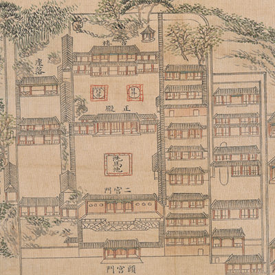
The atlas consists of 23 color maps in silk; each map offers a subtitle and explanatory text. The atlas was fused with traditional Chinese landscape elements: the composition and the harmonious spatial design of flowers, gardens, and buildings convey the mapmaker’s ingenuity; the atlas is depicted with texture brushstroke, the arrangements mix objects from far and near, rendering a fresh, panoramic, and harmonious view.
Emperor Qianlong reigned for 60 years from 1736 to 1796. He made six southern inspections tours in 1751, 1757, 1762, 1765, 1780, and 1784. According to the Qing Dynasty’s rules, local officials must prepare planning blueprints for emperors’ resting places along the tour. These detailed blueprints were presented to the emperor for review. The blueprints include route maps, rest stops, scenery spots, mileages, local history and geography, etc.
There were 23 temporary palaces built for Qianlong’s southern inspection tours, almost all of them are located along the Grand Canal from Suzhou to Suqian County:
1. Lingyan Mountain Palace (Suzhou);
2. Huiji Temple (Qinghe County, Huai’an Prefecture);
3. Chenjiazhuang Palace (Taoyuan County);
4. Guijiazhuang Palace (Qinghe County);
5. Linjiazhuang Palace (Taoyuan County);
6. Han Fu (Textile Workshop, Hui City east, Jiangning Prefecture);
7. Huqiu Palace (Suzhou);
8. Shunheji Palace (Suqian County, by the east bank of the Grand Canal);
9. Huiyin Temple (Yangzhou, used to be Sheli Temple);
10. Dengwei Mountain (70 li southwest of Suzhou Prefecture);
11. Shuizhuju (Yangzhou);
12. Gaoyonglou (Yangzhou);
13. Chaotian Palace (Yangzhou);
14. Fajing Temple (Yangzhou, aka Guqiling Monastery and Daming Temple);
15. Gaomin Monastery Palace (Sancha River, 15 li south of Yangzhou);
16. Linggu Temple (southeast of Zhong Mountain, Jiangning Prefecture);
17. Longtan Palace (80 li northwest of Jurong County);
18. Jiming Mountain (northeast of Jiangning Prefecture);
19. Heshen Temple (Dam on Yellow River, Qingjiang County);
20. Dengwei Mountain Palace (Suzhou);
21. Jiangning Palace (Jiangning Textile Department);
22. Kang Mountain (Yangzhou);
23. Longquan village Palace (Suqian County).
The atlas was drawn by different officials in different times. The atlas may have been drawn during Qianlong’s fourth and fifth tours, 1765-1780.
This map can be contrasted with the following maps in the National Palace Museum’s collection: Qianlong nan xun ji cheng tu (map no. 020803-020818); Shimen Zhen bei di er zhan zhi Haining Xian Tangqi Zhen Daying dao li tu shuo (map no. 020819); Tangqi Zhen di san zhan zhi sheng cheng nei xing gong dao li tu shuo (map no. 020820); Haining Chenyuan di si zhan zhi sheng cheng nei xing gong dao li tu shuo (map no. 020821); and the Library of Congress collection: Anlanyuan zhi Jianshan qi zuo dao li tu shuo (gm 85693767); Anlanyuan zhi Hangzhou Fu xing gong dao li tu shuo (gm 2002626740); Zhejiang Sheng yuan fang xiang quan tu (gm 71005032); Zhejiang Sheng yuan shui li quan tu (gm 89691149).