Maps of Social and Economic Conditions
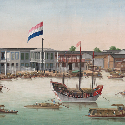
廣州城珠江灘景圖
The Waterfront at Canton| Hanyu Pinyin | Guangzhou Cheng Zhujiang tan jing tu |
|---|---|
| Date | Around the 10th year of Qing Daoguang's reign, 1831. |
| Measurement | |
| Techniques | Ink and color manuscript |
| Material | silk |
| Quantity | |
| Categories | |
| Country of Repository | |
| Identifier | British Library |
| Link to Original Database | http://explore.bl.uk/primo_library/... |
| Notes | Maps K.Top.116.23 |
| Share |
No title appears on this map; the title applied here is based on content. The map vividly depicts Canton and the Pearl River in a realist style, including people, riverside houses, boats, merchants, pavilions, and foreign firm buildings. There is no expressed orientation; the map shows the scenery from one side of the Pearl River.
The Imperial Guangdong Customs flag is depicted. According to the Daoguang Annals of Guangdong, the Imperial Guangdong Customs was established when the ban to Southeast Asia was lifted in the 24th year of Kangxi’s reign, 1685; it went through several changes from 1685 to 1750. In 1815, over 100 foreign boats were spotted in the area. The map also shows flags of Netherlands, the United Kingdom, Sweden, Denmark, and others on the respective foreign firm buildings.
A building code established in 1829; permits were needed for architectural style, walls had to be a meter thick only, wooden front, the length and width of construction timber for side wall fences was specified. Based on the British building style, the map may have been drawn around the 10th year of Daoguang’s reign, 1831.
This map can be contrasted with the following maps in the National Palace Museum’s collection: Guangdong Sheng shu ge zhou fu xian di yu tu shuo (map no.021157); Guangdong Sheng di tu (map no. 021477); Guangdong zhi Xingluo shui lu dao li tu (Grand Council no. 010186); and the Library of Congress collection: Guangdong quan tu (gm 71005120); Guangdong tong sheng shui dao tu (gm 71002467); Guangdong quan sheng shui lu yu tu (gm 71005159).