Maps of Social and Economic Conditions
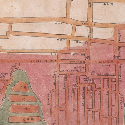
廣州城西關外及十三行圖
Map of Foreign Firms Area of Canton| Hanyu Pinyin | Guangzhou cheng xi guan wai ji shi san hang tu |
|---|---|
| Date | After the second year of Qing Daoguang's reign, 1822-. |
| Measurement | |
| Techniques | Ink and color manuscript |
| Material | paper |
| Quantity | |
| Categories | |
| Country of Repository | |
| Identifier | British Library |
| Link to Original Database | http://explore.bl.uk/primo_library/... |
| Notes | Add. MS. 16358 (A) |
| Share |
No title appears on this map; the title applied here is based on content. Scale, legend, and orientation are not given. However, judging from the map, north is at the top. The map covers the area from Taiping Gate of Canton to the West Fort of the northern bank; from Qinglong Xun of Wanshangli in the north to the Pearl River in the south. Most features are depicted in simple lines except the Thirteen Factories and some flood forts. All place names are indicated and the area of foreign firms are colored in red. In addition, distance was given in the text on the bottom. The red section is the area damaged by the big fire that broke out in 1822. The fire lasted for two days and spread to 2,000 merchants, businesses, and houses.
This map can be contrasted with the following maps in the National Palace Museum’s collection: Guangdong Sheng shu ge zhou fu xian di yu tu shuo (map no. 021157); Guangdong Sheng di tu (map no. 021477); Guangdong zhi Xingluo shui lu dao li tu (Grand Council no. 010186); and the Library of Congress collection: Guangdong quan tu (gm 71005120); Guangdong tong sheng shui dao tu (gm 71002467); Guangdong quan sheng shui lu yu tu (gm 71005159).
This map can be contrasted with the following maps in the National Palace Museum’s collection: Guangdong Sheng shu ge zhou fu xian di yu tu shuo (map no. 021157); Guangdong Sheng di tu (map no. 021477); Guangdong zhi Xingluo shui lu dao li tu (Grand Council no. 010186); and the Library of Congress collection: Guangdong quan tu (gm 71005120); Guangdong tong sheng shui dao tu (gm 71002467); Guangdong quan sheng shui lu yu tu (gm 71005159).