Maps of Social and Economic Conditions
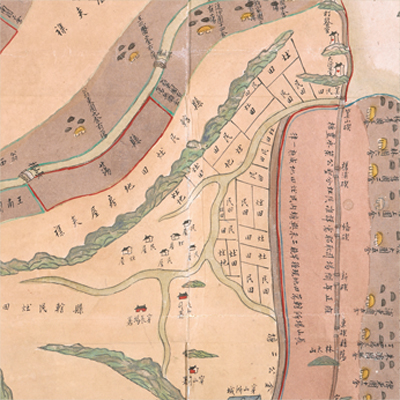
寧波府鎮海縣土地分類圖
Map of Land Distribution in Zhenhai County| Hanyu Pinyin | Ningbo Fu Zhenhai Xian tu di fen lei tu |
|---|---|
| Date | After the 39th year of Qing Qianlong's reign, 1774-. |
| Measurement | |
| Techniques | Ink and color manuscript on paper |
| Material | paper |
| Quantity | |
| Categories | |
| Country of Repository | |
| Identifier | British Library |
| Notes | Or. 14554 |
| Share |
No title appears on this map; the title applied here is based on content. No scale or legend is given; orientation is marked along the borders on all four sides with north at the top. The map mainly covers Zhenhai County in Ningbo Prefecture. Dinghai County changed its name to Zhenhai in the 26th year of Kangxi’s reign, 1687. The map depicts land distribution and land use at all levels. The map shows county-owned and private-owned intertidal mudflats, wetlands, farmlands, and salt-making fields. The slat-making fields, wetlands and county-owned intertidal mudflats are everywhere on the map, but the areas of private-owned farmlands are rather small. The map may have been drawn around the 39th year of Qing Qianlong’s reign, 1774, based on the well-known dam projects illustrated on the map.
This map can be contrasted with the following maps in the National Palace Museum’s collection: Shimen Zhen bei di er zhan zhi Haining Xian Tangqi Zhen Daying dao li tu shuo (map no. 020819); Zhejiang Sheng hai tang tu (map no. 020880); Zhejiang Fujian yan hai hai fang tu (map no. 020869); Zhejiang Shaoxing Fu shu di li yu tu (map no. 020966); Zhejiang Shaoxing Fu di yu tu shuo (map no. 021309); Zhejiang Shaoxing Fu dao li tu (map no. 021492); Zhejiang Shaoxing Fu shu di tu (map no. 021520); and the Library of Congress collection: Zheijiang quan tu (gm 71005029); Jiang hai quan tu (gm 71005059); Zhejiang yan hai yao kou quan tu (gm 2002626763); Ning Jun di yu tu (gm 71002469).
This map can be contrasted with the following maps in the National Palace Museum’s collection: Shimen Zhen bei di er zhan zhi Haining Xian Tangqi Zhen Daying dao li tu shuo (map no. 020819); Zhejiang Sheng hai tang tu (map no. 020880); Zhejiang Fujian yan hai hai fang tu (map no. 020869); Zhejiang Shaoxing Fu shu di li yu tu (map no. 020966); Zhejiang Shaoxing Fu di yu tu shuo (map no. 021309); Zhejiang Shaoxing Fu dao li tu (map no. 021492); Zhejiang Shaoxing Fu shu di tu (map no. 021520); and the Library of Congress collection: Zheijiang quan tu (gm 71005029); Jiang hai quan tu (gm 71005059); Zhejiang yan hai yao kou quan tu (gm 2002626763); Ning Jun di yu tu (gm 71002469).