Military and Traffic Maps
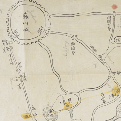
蘇州無錫之間水道圖
Map of the Waterways between Suzhou and Wuxi| Hanyu Pinyin | Suzhou Wuxi zhi jian shui dao tu |
|---|---|
| Date | Between Qing Xianfeng and Tongzhi period, 1855-1864. |
| Measurement | |
| Techniques | Pen-and-ink manuscript on paper |
| Material | paper |
| Quantity | |
| Categories | |
| Country of Repository | |
| Identifier | British Library |
| Notes | Or. 2338 (32) 7 |
| Share |
No title appears on the map; the title applied here is based on content. No scale or legend is given; orientation is marked along the borders on all four sides with north at the bottom. The town walls, bridges are depicted pictorially. The map includes annotations. Wuxi County is under the jurisdiction of Changzhou Prefecture and is 49 li northwest of Suzhou prefectural seat. The map covers the south of Changshu County of Suzhou Prefecture, around the area of Changzhou County and Wuxi County. The map does not give enough information about when the map was made. However, since the map is one of Charles George Gordon’s No. 32 collection, it may have been drawn during Xianfeng and Tongzhi period, 1855-1864.
This map can be contrasted with the following maps in the National Palace Museum’s collection: Changjiang di li tu (map no. 020878); Changjiang tu (map no. 020879); Jiangnan ge dao fu tu biao cun (map no. 020923-020941); Jiangnan quan sheng dao li zong tu (map no. 021560); Jiangsu hai fang tu (map no. 021513); Ping ding yue fei zhan tu san shi jiu zhang (map no. 021283.001-021294.002); and the Library of Congress collection: Jiangsu quan tu (gm 71005111).
This map can be contrasted with the following maps in the National Palace Museum’s collection: Changjiang di li tu (map no. 020878); Changjiang tu (map no. 020879); Jiangnan ge dao fu tu biao cun (map no. 020923-020941); Jiangnan quan sheng dao li zong tu (map no. 021560); Jiangsu hai fang tu (map no. 021513); Ping ding yue fei zhan tu san shi jiu zhang (map no. 021283.001-021294.002); and the Library of Congress collection: Jiangsu quan tu (gm 71005111).