City Maps
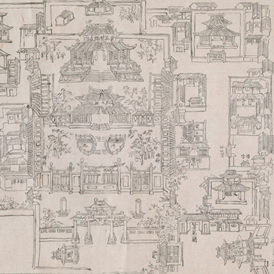
杭州省城、海塘、府學圖
Capital City, Seawall, and Prefectural School of Hangzhou| Hanyu Pinyin | Hangzhou Sheng cheng, hai tang, fu xue tu |
|---|---|
| Date | The 49th year of Qing Qianlong's reign, 1784. |
| Measurement | |
| Techniques | Pen-and-ink manuscript on paper |
| Material | paper |
| Quantity | |
| Categories | |
| Country of Repository | |
| Identifier | British Library |
| Link to Original Database | http://explore.bl.uk/primo_library/... |
| Notes | Maps 162.b.1 |
| Share |
The three maps are from Qianlong Hangzhou Gazetteers: capital city, seawall, and prefectural schools. The three maps are all vividly depicted with north at the top and titles written on the upper right. Hangzhou Gazetteers was compiled in the 49th year of Qianlong’s reign, 1784, compiled by Zheng Yun, the prefect of Hangzhou, edited by Shao Jinhan (1743-1796) who was an expert in history and was known for his work for the famous Four Books.
Hangzhou Gazetteers includes 21 maps: the West Lake, Xingye, Hui City, Hangzhou territory, prefectural schools, prefectural government, Qiantang County, Rehe County, Hainingzhou, Fuyang County, Yuhang County, Lin’an County, Yuqian County, Xincheng County, Changhua County, Wulin Mountain, Tianmu Mountain, Qiantang River, seawall, the West Lake II, and the old city map from Southern Song Dynasty. All maps are accompanied with explanatory text.
This map can be contrasted with the following maps in the National Palace Museum’s collection: Zhejiang Sheng hai tang tu (map no. 020880); Jingkou yi xia Xiyang Yunhe yi dai he hu zhi Hangzhou qing xing (map no. 020881); Zhejiang Hangzhou Fu shu di li yu tu (map no. 020962); Hangzhou tu (map no. 021484); Zhejiang Qiantang Jiang shui lu tu (grand council document no. 033184); and the Library of Congress collection: Anlanyuan zhi Jianshan qi zuo dao li tu shuo (gm 85693767); Anlanyuan zhi Hangzhou Fu xing gong dao li tu shuo (gm 2002626740); Zhejiang Sheng yuan fang xiang quan tu (gm 71005032); Zhejiang Sheng yuan shui li quan tu (gm 89691149).