City Maps
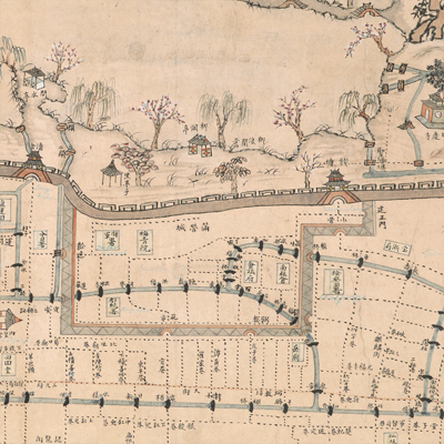
杭城西湖江干湖墅圖
Landscape of Hangzhou| Hanyu Pinyin | Hang Cheng Xihu jiang gan hu su tu |
|---|---|
| Date | Between late Kangxi and early Yongzheng period, 1716-1727. |
| Measurement | |
| Techniques | Ink and color manuscript |
| Material | paper |
| Quantity | |
| Categories | |
| Country of Repository | |
| Identifier | British Library |
| Link to Original Database | http://explore.bl.uk/primo_library/... |
| Notes | Maps Tab.1.e.2 |
| Share |
The title is written in black ink on the right. The map combines the traditional Chinese painting skills and mapping techniques, and depicts the landscape of Hangzhou, the West Lake, Renhe County in the north, and Qiantang County in the south. There is no expressed legend, scale or orientation, but obviously west is at top. All place names are marked; streets, lanes, waterways, and bridges inside Hangzhou city are annotated in detail; the West Lake, temples, attractions, and surrounding mountains outside Hangzhou are also annotated in great detail. The Qiantang River is represented by blank areas with some text on the right. The map may have been drawn during Late Kangxi and Early Yongzheng period, 1716-1727.
This map can be contrasted with the following maps in the National Palace Museum’s collection: Qianlong nan xun ji cheng tu (map no. 020803-020818); Shimen Zhen bei di er zhan zhi Haining Xian Tangqi Zhen Daying dao li tu shuo (map no. 020819); Tangqi Zhen di san zhan zhi sheng cheng nei xing gong dao li tu shuo (map no. 020820); Haining Chenyuan di si zhan zhi sheng cheng nei xing gong dao li tu shuo (map no. 020821); Zhejiang Hangzhou Fu shu di li yu tu (map no. 020962); and the Library of Congress collection: Anlanyuan zhi Jianshan qi zuo dao li tu shuo (gm 85693767); Anlanyuan zhi Hangzhou Fu xing gong dao li tu shuo (gm 2002626740); Zhejiang Sheng yuan fang xiang quan tu (gm 71005032); Zhejiang Sheng yuan shui li quan tu (gm 89691149).
This map can be contrasted with the following maps in the National Palace Museum’s collection: Qianlong nan xun ji cheng tu (map no. 020803-020818); Shimen Zhen bei di er zhan zhi Haining Xian Tangqi Zhen Daying dao li tu shuo (map no. 020819); Tangqi Zhen di san zhan zhi sheng cheng nei xing gong dao li tu shuo (map no. 020820); Haining Chenyuan di si zhan zhi sheng cheng nei xing gong dao li tu shuo (map no. 020821); Zhejiang Hangzhou Fu shu di li yu tu (map no. 020962); and the Library of Congress collection: Anlanyuan zhi Jianshan qi zuo dao li tu shuo (gm 85693767); Anlanyuan zhi Hangzhou Fu xing gong dao li tu shuo (gm 2002626740); Zhejiang Sheng yuan fang xiang quan tu (gm 71005032); Zhejiang Sheng yuan shui li quan tu (gm 89691149).