City Maps
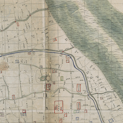
上海縣城廂租界全圖
Downtown Map of Shanghai County and Concession Areas| Hanyu Pinyin | Shanghai xian cheng xiang zu jie quan tu |
|---|---|
| Creator | Qiu Yufu, Xu Yucang |
| Date | The first year of Qing Guangxu's reign, 1875. |
| Measurement | |
| Techniques | Ink and color on paper |
| Material | paper |
| Quantity | |
| Categories | |
| Country of Repository | |
| Identifier | British Library |
| Notes | Or. 15406.a.58 |
| Share |
Title is written on the upper right. There is no expressed legend. The map adopted the traditional Chinese grid scale: each grid represents 45 zhang, and every four grids are 100 li (approximately 33 miles); North is at the top. Although the Wusong River is slightly smaller on the top of map, it stands out among other features. The distribution of streets, rivers, bridges, government offices, courts, barracks, public and private plants, associations, colleges, temples, and churches are clearly illustrated. The concession sections are marked.
Li Fengbao (1834-1887), Qing Dynasty’s ambassador to Austria, Italy, the Netherlands, France, wrote a preface and explained the background of the map’s creation. The mapmaker incorporated some modern mapping skills and rendered a masterly designed city map. The map was drawn in the first year of Qing Guangxu’s reign, 1875, and was later copied by other cartographers.
This map can be contrasted with the following maps in the National Palace Museum’s collection: Jiangsu hai fang tu (map no. 021513); Baoshan Xian hai tang tu (Grand Council file no. 046243-a); Ge sheng yan hai kou ai quan tu (map no. 020867); Yan hai an chang tu (map no. 020868); Jiangnan ge dao fu tu biao cun (map no. 020923-020941); and the Library of Congress collection: Jiangsu quan tu (gm 71005111).