City Maps
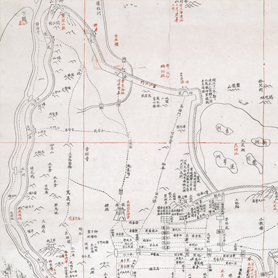
江寧省城圖
Urban Plan of Jiangning| Hanyu Pinyin | Jiangning Sheng cheng tu |
|---|---|
| Creator | Deng Qixian |
| Date | Before the third year of Qing Xianfeng's reign, -1853. |
| Measurement | |
| Techniques | Ink and color on paper |
| Material | paper |
| Quantity | |
| Categories | |
| Country of Repository | |
| Identifier | British Library |
| Link to Original Database | http://explore.bl.uk/primo_library/... |
| Notes | Maps Tab.1.d.2 |
| Share |
No title appears on this map; the title applied here is based on content. Legend is not given on the map. Notes along the right bottom cite scale and orientation. The Chinese scale is each grid represents 10 li, north is at the top. The bird’s eye view depicts government offices, streets, bridges, temples, monasteries, and barracks. Only the town walls and towers are pictorially depicted; some places are marked in red for emphasis, to show changes, or to differentiate certain buildings or places; extensive explanatory text recorded the history and development of Nanjing. Most of the text and cartographic information are from “Map of Jiangning Prefecture” (Or. 5502). The provincial capital of Jiangning was once occupied by the Taiping army and many buildings were built after the Tongzhi period. Many buildings on this map were built before the occupation.
This map can be contrasted with the following maps in the National Palace Museum’s collection: Jinling ge ying lu jie jie wei tu (map no. 021291.001); Jinling ge ying lu jie jie wei tu shuo (map no. 021291.002); Ke fu Jinling tu (map no. 021293.001); and the Library of Congress collection: Jiangsu quan tu (gm 71005111); Qing jun wei gong Jinling Cheng tu (gm 71005033).
This map can be contrasted with the following maps in the National Palace Museum’s collection: Jinling ge ying lu jie jie wei tu (map no. 021291.001); Jinling ge ying lu jie jie wei tu shuo (map no. 021291.002); Ke fu Jinling tu (map no. 021293.001); and the Library of Congress collection: Jiangsu quan tu (gm 71005111); Qing jun wei gong Jinling Cheng tu (gm 71005033).