Local Administrative Maps
臺灣里堡圖
Administrative Map of Taiwan Island| Hanyu Pinyin | Taiwan li bao tu |
|---|---|
| Date | Between late Qing Jiaqing and early Daoguang period, 1820-1829. |
| Measurement | |
| Techniques | Ink and color manuscript |
| Material | silk |
| Quantity | |
| Categories | |
| Country of Repository | |
| Identifier | British Library |
| Link to Original Database | http://explore.bl.uk/primo_library/... |
| Notes | Add. MS. 16357 |
| Share |
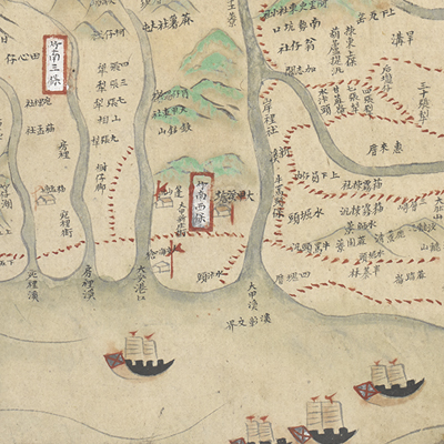
No title appears on this map; the title applied here is based on content. No scale, legend, or orientation is given, but obviously east is at the top. The 10-folds map covers mainly west Taiwan and Penghu island: from Mianhua Islet outside the Keelung Coast in the north to Lamay Island in the south, and from Central Mountain Range in the east to the west coast including Penghu Island. The east part was recorded only the name of the aboriginal hamlets and mountains, except the region of Kavalan was recorded in detail. The place names were written in black; and there are many of the red frames with white background noted “bao” and “li”, the basic administrative units, all over the map.
The town walls of one prefecture and three counties were clearly drawn on the map, but the marks indicating town sites of Kavalan and Tamsui Sub-prefectures were not drawn like walls. However, by the time the map was drawn, the town walls of Kavalan may have been built. Before Kavalan was assigned to be sub-prefecture, the prefect Yang Tingli, built the wall in the 15th year of Jiaqing’s reign, 1810. The Gengfang Mountain Pass shown on the map was built in the 24th year of Jiaqing’s reign, 1819, by Gao Dayong at the north side of Kavalan.
Tamsui sub-prefect Cha Tinghua expanded the town wall of Tamsui based on the old retaining wall. In the sixth year of Daoguang’s reign, 1826, the wall was asked to be rebuilt. In August of the ninth year of Daoguang’s reign, 1829, the wall was completed. As a result, one can assumed that the map was drawn after the 24th year of Jiaqing’s reign to the ninth year of Daoguang’s reign, 1819-1829.
This map can be contrasted with the following maps in the National Palace Museum’s collection: Taiwan lue tu (map no. 021444, 021445); Yongzheng Taiwan tu fu Penghu qun dao tu (map no. 020794); Qianlong Taiwan di tu (map no. 020795); Zhong xiu Tai Jun ge jian zhu tu shuo (map no. 020970-021048); Fujian Sheng di tu (map no. 021476); and the Library of Congress collection: Taiwan qian hou shan quan tu (gm 71005066); Taiwan di li tu (gm 71005037); Taiwan qian hou shan yu tu (gm 71005160).

