City Maps
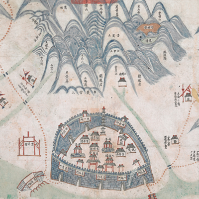
金華縣輿圖
Map of Jinhua County| Hanyu Pinyin | Jinhua Xian yu tu |
|---|---|
| Date | After the third year of Qing Daoguang's reign, 1823-. |
| Measurement | |
| Techniques | Ink and color manuscript |
| Material | paper |
| Quantity | |
| Categories | |
| Country of Repository | |
| Identifier | British Library |
| Link to Original Database | http://explore.bl.uk/primo_library/... |
| Notes | Add. MS. 16359 (D) |
| Share |
No title appears on the map; the title applied here is based on content. Scale and legend are not given. Distances to neighboring county boundaries and orientation are marked along the borders on all four sides. Jinhua County and Zhejiang Prefecture shared the same capital town. The county seat was 93 li long from east to west; 75 li from north to south. The map uses pictorial images to depict geographic features and administration divisions, such as military posts, government offices, bridges, rest stations, tribes and settlements. Distance mileages between jurisdictions are recorded on the map. Based on the information given on the map, this is an official political administrative map presented to higher officials. Hingji and Tongji bridges are pictorially illustrated. This map may have been drawn during early Qing Daoguang period, 1823.
This map can be contrasted with the following maps in the National Palace Museum’s collection: Zhejiang Jinhua Fu dao li tu (map no. 021498); Zhejiang Jinhua Fu ba yi di li tu (map no. 021521); Zhejiang quan sheng tu (map no. 021589); Zhejiang quan sheng dao li zong tu (map no. 021505-021506); and the Library of Congress collection: Zheijiang quan tu (gm 71005029); Zheijiang quan tu (gm 96685902).
This map can be contrasted with the following maps in the National Palace Museum’s collection: Zhejiang Jinhua Fu dao li tu (map no. 021498); Zhejiang Jinhua Fu ba yi di li tu (map no. 021521); Zhejiang quan sheng tu (map no. 021589); Zhejiang quan sheng dao li zong tu (map no. 021505-021506); and the Library of Congress collection: Zheijiang quan tu (gm 71005029); Zheijiang quan tu (gm 96685902).