City Maps
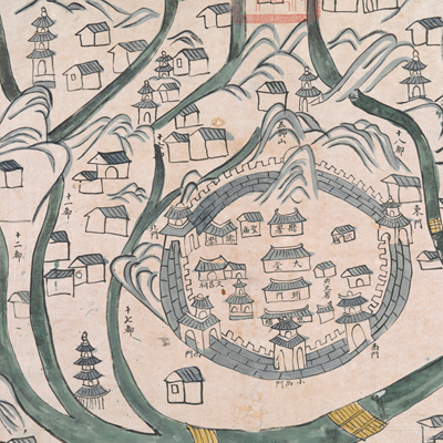
遂安縣山川之圖
Map of Sui'an County| Hanyu Pinyin | Sui’an Xian shan chuan zhi tu |
|---|---|
| Date | Around the 25th year of Qing Daoguang's reign, 1845. |
| Measurement | |
| Techniques | Ink and color manuscript |
| Material | paper |
| Quantity | |
| Categories | |
| Country of Repository | |
| Identifier | British Library |
| Link to Original Database | http://explore.bl.uk/primo_library/... |
| Notes | Add. MS. 16360 (D) |
| Share |
The title is written on the top; there is also an alternative title written on the affixed red label: “Map of Sui’an County of Yanzhou Prefecture in Zhejiang Province.” No scale or legend is given; neighboring counties and orientation are noted along the borders on all four sides with north at the top. Sui’an County was 180 li west of Yanzhou prefectural seat in Zhejiang Province. The total width from east to west was 123 li, and the length from north to south was 124 li. (See: Qianlong Zhejiang Annals, vol. 3). All rivers passed through Wuqiang Creek, and merged into the Xin’an River. In 1958, Sui’an County was assimilated into Chun’an County, and in 1959, the county seat became part of the Xin’an River Reservoir (See: China Dictionary of Ancient and Modern Chinese Geographical Names, 2005, p. 2,924). The map applied the traditional pictorial style in depicting government offices, temples, bridges, and villages. The five gates of the town walls are deliberately exaggerated. The official seal of Sui’an was stamped on the top in Manchu and Han Chinese. Based on the information on the map, the map may have been drawn in the 25th year of Qing Daoguang’s reign, 1845.
This map can be studied with the following maps in the National Palace Museum’s collection: Zhejiang Yanzhou Fu dao li tu (map no. 021495); Zhejiang quan sheng dao li zong tu (map no. 021505-6); Zhejiang quan sheng tu (map no. 021589); and the Library of Congress collection: Zheijiang quan tu (gm 71005029); Zhejiang yan hai yao kou quan tu (gm 2002626763); Ning Jun di yu tu (gm 71002469).
This map can be studied with the following maps in the National Palace Museum’s collection: Zhejiang Yanzhou Fu dao li tu (map no. 021495); Zhejiang quan sheng dao li zong tu (map no. 021505-6); Zhejiang quan sheng tu (map no. 021589); and the Library of Congress collection: Zheijiang quan tu (gm 71005029); Zhejiang yan hai yao kou quan tu (gm 2002626763); Ning Jun di yu tu (gm 71002469).