City Maps
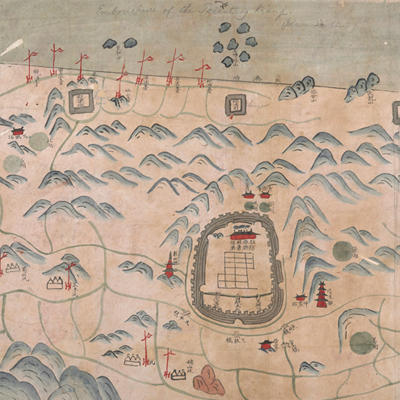
寧波府暨慈谿縣輿圖
Map of Ningbo Prefecture and Cixi County| Hanyu Pinyin | Ningbo Fu ji Cixi Xian yu tu |
|---|---|
| Date | After the sixth year of Qing Daoguang’s reign, 1826-. |
| Measurement | |
| Techniques | Ink and color manuscript |
| Material | paper |
| Quantity | |
| Categories | |
| Country of Repository | |
| Identifier | British Library |
| Notes | Add. MS. 16360 (F) |
| Share |
Original title “Shu Zhejiang Ningbo Fu Cixi Xian cheng song yu tu” was written on a red label affixed to the verso of the map. Scale and legend are not given. Orientation is marked along the borders on all four sides with north at the top. The map uses pictorial images to depict geographic features, cultural landscapes, and administration divisions, such as towns, mountains, pagodas, and flood seasons. The capital town of Cixi County is exaggerated to emphasize its importance as the northwest gateway for Ningbo along the Qiantang River. Several English annotations are found on the map, such as the one marked on top of the Qiantang River as “embouchure of the Tsientang Kiang.” The map was most likely used by westerners at the time, and may have been drawn after the sixth year of Daoguang’s reign, 1826.
This map can be contrasted with the following maps in the National Palace Museum’s collection: Zhejiang Ningbo Fu di yu tu shuo (map no. 020965); Zhejiang Ningbo Fu dao li tu (map no. 021491); Zhejiang Ningbo Fu shu di li yu tu (map no. 021510); Zhejiang Fujian yan hai hai fang tu (map no. 020869); Zhejiang Sheng hai tang tu (map no. 020880); Zhejiang Shaoxing Fu shu di li yu tu (map no. 020966); Zhejiang Shaoxing Fu di yu tu shuo (map no. 021309); Zhejiang Shaoxing Fu dao li tu (map no. 021492); Zhejiang Shaoxing Fu shu di tu (map no. 021520); and the Library of Congress collection: Zheijiang quan tu (gm 71005029); Jiang hai quan tu (gm 71005059); Zhejiang yan hai yao kou quan tu (gm 2002626763); Ning Jun di yu tu (gm 71002469).
This map can be contrasted with the following maps in the National Palace Museum’s collection: Zhejiang Ningbo Fu di yu tu shuo (map no. 020965); Zhejiang Ningbo Fu dao li tu (map no. 021491); Zhejiang Ningbo Fu shu di li yu tu (map no. 021510); Zhejiang Fujian yan hai hai fang tu (map no. 020869); Zhejiang Sheng hai tang tu (map no. 020880); Zhejiang Shaoxing Fu shu di li yu tu (map no. 020966); Zhejiang Shaoxing Fu di yu tu shuo (map no. 021309); Zhejiang Shaoxing Fu dao li tu (map no. 021492); Zhejiang Shaoxing Fu shu di tu (map no. 021520); and the Library of Congress collection: Zheijiang quan tu (gm 71005029); Jiang hai quan tu (gm 71005059); Zhejiang yan hai yao kou quan tu (gm 2002626763); Ning Jun di yu tu (gm 71002469).