City Maps
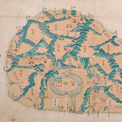
定海縣全圖
Map of Dinghai County| Hanyu Pinyin | Dinghai Xian quan tu |
|---|---|
| Date | Before the 21st year of Qing Daoguang’s reign, -1841. |
| Measurement | |
| Techniques | Ink and color manuscript |
| Material | paper |
| Quantity | |
| Categories | |
| Country of Repository | |
| Identifier | British Library |
| Link to Original Database | http://explore.bl.uk/primo_library/... |
| Notes | Add. MS. 16360 ( E) |
| Share |
No title appears on this map; the title applied here is based on content. No scale or legend is given; orientation is marked along the borders on all four sides with north at the top. The map depicts the geographic features of Dinghai town and all Zhoushan Island, including mountains, rivers, waterways, bridges, flood seasons, and major roads. Roads between mountains are indicated in red dotted lines. Dinghai town on the bottom left is the only city on Zhoushan Island. According to Zhejiang Annals, it was originally named as Zhoushan, and was changed to Dinghai Mountain in 1686. Later, it was established as Dinghai County in 1688. The map may have been drawn before the 21st year of Qing Daoguang’s reign, 1841.
This map can be contrasted with the following maps in the National Palace Museum’s collection: Hai tu (map no. 020865); Ge sheng yan hai kou ai quan tu (map no. 020867); Zhejiang Ningbo Fu di yu tu shuo (map no. 020965); Zhejiang Ningbo Fu dao li tu (map no. 021491); Zhejiang Ningbo Fu shu di li yu tu (map no. 021510); Zhejiang Fujian yan hai hai fang tu (map no. 020869); Yan hai an chang tu (map no. 020868); Zhejiang Shaoxing Fu shu di li yu tu (map no. 020966); Zhejiang Shaoxing Fu di yu tu shuo (map no. 021309); and the Library of Congress collection: Zheijiang quan tu (gm 71005029); Zheijiang quan tu (gm 96685902); Jiang hai quan tu (gm 71005059); Hai jiang yang jie xing shi tu (gm 71005021); Qi sheng yan hai quan tu (gm 71005064); Zhejiang yan hai yao kou quan tu (gm 2002626763).
This map can be contrasted with the following maps in the National Palace Museum’s collection: Hai tu (map no. 020865); Ge sheng yan hai kou ai quan tu (map no. 020867); Zhejiang Ningbo Fu di yu tu shuo (map no. 020965); Zhejiang Ningbo Fu dao li tu (map no. 021491); Zhejiang Ningbo Fu shu di li yu tu (map no. 021510); Zhejiang Fujian yan hai hai fang tu (map no. 020869); Yan hai an chang tu (map no. 020868); Zhejiang Shaoxing Fu shu di li yu tu (map no. 020966); Zhejiang Shaoxing Fu di yu tu shuo (map no. 021309); and the Library of Congress collection: Zheijiang quan tu (gm 71005029); Zheijiang quan tu (gm 96685902); Jiang hai quan tu (gm 71005059); Hai jiang yang jie xing shi tu (gm 71005021); Qi sheng yan hai quan tu (gm 71005064); Zhejiang yan hai yao kou quan tu (gm 2002626763).