Local Administrative Maps
無錫金匱輿地全圖
Complete Map of Wuxi Jingui County| Hanyu Pinyin | Wuxi Jingui yu di quan tu |
|---|---|
| Date | Between Qing Xianfeng and Tongzhi period, 1860-1866. |
| Measurement | |
| Techniques | Ink and color manuscript |
| Material | paper |
| Quantity | |
| Categories | |
| Country of Repository | |
| Identifier | British Library |
| Notes | Or. 2338 (32) 9 |
| Share |
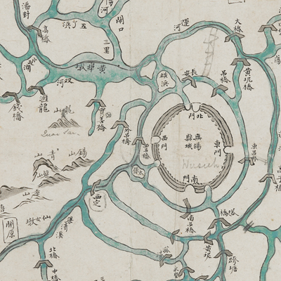
Original title was: “Wuxi, Jingui er xian tong cheng si zhi di yu quan tu.” The title applied is more pertinent to content. No scale or legend is given; orientation is marked along the borders on all four sides. The map covers the areas governed by Wuxi County, Changzhou Prefecture in Jiangsu Province. Wuxi was 90 li southwest of the prefecture and was divided into two counties, Wuxi and Jingui, in 1724. In 1912, Jingui and Wuxi counties merged into Wuxi County.
The map depicts the mountains, waterways, lakes, piers, ferries, bridges, dykes, and municipalities in Wuxi County. Tai Lake is in the lower left; the symbol for water is different from the depiction of Cao Lake, E Lake, Nanyang Lake, and all rivers. Waterways are crisscrossed; bridges on canals are numerous and densely distributed.
This map can be contrasted with the following maps in the National Palace Museum’s collection: Changjiang di li tu (map no. 020878); Changjiang tu (map no. 020879); Jiangnan ge dao fu tu biao cun (map no. 020923-020941); Jiangnan quan sheng dao li zong tu (map no. 021560); Jiangsu hai fang tu (map no. 021513); Ping ding yue fei zhan tu san shi jiu zhang (map no. 021283.001-021294.002); and the Library of Congress collection: Jiangsu quan tu (gm 71005111); Changjiang shui shi Guazhou Zhen Biaozhong Ying jiang xu quan tu (gm 80692824); Qing jun wei gong Jinling Cheng tu (gm 71005033).