Local Administrative Maps
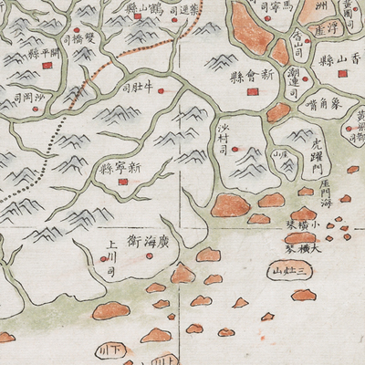
廣東全省經緯地輿圖
General Map of Guangdong Province| Hanyu Pinyin | Guangdong quan sheng jing wei di yu tu |
|---|---|
| Creator | Li Mingche |
| Date | Between Qing Jiaqing and Daoguang period, 1816-1832. |
| Measurement | |
| Techniques | Ink and color manuscript |
| Material | paper |
| Quantity | |
| Categories | |
| Country of Repository | |
| Identifier | British Library |
| Link to Original Database | http://explore.bl.uk/primo_library/... |
| Notes | Maps 61670 (4) |
| Share |
Title is written on the top right. No orientation or legend is given, but north is obviously at the top and the legend follows a self-contained set of rules. The preface clearly illustrates the mapping specifications of latitude and longitude; latitude is from 18 degrees running through Qiongzhou in the south to 25.5 degrees through the border of Nanxiongzhou and Jiangxi Dayu County in the north; longitude running from Beijing to Chaozhou is the central line. A chart of latitude and longitude of counties in Guandong is given on the left. A postscript “Li Mingche” is also stamped on the map. Li Mingche (1751-1832, also known as Dagang, Feiyun, and Qinglai) became a priest in a Dao temple when he was young. He was knowledgeable about astronomical observation, geographic mapping, and trigonometry. He applied “equal area azimuthal projection” in map making. The method created by the German scholar Lambert (J. H. Lambert, 1728-1777) was known as the “Lambert zenithal equal-area projection.” The map is mainly an administrative distribution map. The map may have been drawn during Jiaqing and Daoguang period, 1816-1832.
This map can be contrasted with the following maps in the National Palace Museum’s collection: Guangdong Sheng di tu (map no. 021477); Guangdong Sheng shu ge zhou fu xiang di yu tu shuo (map no. 021157); and the Library of Congress collection: Guangdong quan tu (gm 71005120); Guangdong tong sheng shui dao tu (gm 71002467); Guangdong quan sheng shui lu yu tu (gm 71005159); Dian Yue Yuenan lian jie yu tu (gm 71005069).
This map can be contrasted with the following maps in the National Palace Museum’s collection: Guangdong Sheng di tu (map no. 021477); Guangdong Sheng shu ge zhou fu xiang di yu tu shuo (map no. 021157); and the Library of Congress collection: Guangdong quan tu (gm 71005120); Guangdong tong sheng shui dao tu (gm 71002467); Guangdong quan sheng shui lu yu tu (gm 71005159); Dian Yue Yuenan lian jie yu tu (gm 71005069).