Local Administrative Maps
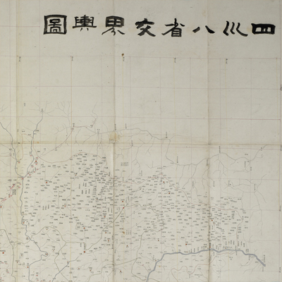
四川八省交界輿圖
Map of Sichuan Province| Hanyu Pinyin | Sichuan ba sheng jiao jie yu tu |
|---|---|
| Creator | Yang Weifan |
| Date | Between Qing Tongzhi and Guangxu period, 1863-1899. |
| Measurement | |
| Techniques | Woodcut and color |
| Material | paper |
| Quantity | |
| Categories | |
| Country of Repository | |
| Identifier | British Library |
| Link to Original Database | http://explore.bl.uk/primo_library/... |
| Notes | Maps 6.d.44 |
| Share |
The title is written on the upper right and reflects the coverage of the map; the legend appears on the bottom right. The map uses the Chinese cartographic grid and a side of each grid represents 100 li (approximately 33 miles). Longitude and latitude are engraved along the borders on all four sides. The text on the bottom left written by Yang Weifan (1811-1899) stated that the map copied its boundaries, place names, and rivers from the “Map of Imperial China and Foreign Lands”, but the map may not be consistent with the information given by the Sichuan Annals or General Annals because the modern surveys were not available when the annals were written. The map may have been drawn during Qing Tongzhi and Guangxu period, 1863-1899.
This map can be contrasted with the following maps in the National Palace Museum’s collection: Sichuan Sheng si lu guan yi tu (map no. 020801); Sichuan quan sheng dao li zong tu (map no. 021540-021542); Sichuan Sheng tu (map no. 021459); Ping ding Jinchuan tu (map no. 021192-021223); and the Library of Congress collection: Sichuan quan tu (gm 71005122); Quan Chuan ying xun zeng bing tu (gm 71005070); Shan jing shu dao tu (gm 71005016).
This map can be contrasted with the following maps in the National Palace Museum’s collection: Sichuan Sheng si lu guan yi tu (map no. 020801); Sichuan quan sheng dao li zong tu (map no. 021540-021542); Sichuan Sheng tu (map no. 021459); Ping ding Jinchuan tu (map no. 021192-021223); and the Library of Congress collection: Sichuan quan tu (gm 71005122); Quan Chuan ying xun zeng bing tu (gm 71005070); Shan jing shu dao tu (gm 71005016).